
|
|
Eric Thorsos
Principal Physicist
Ocean Acoustics Dept.
Applied Physics Laboratory
University of Washington
Kevin Williams
Principal Physicist
Ocean Acoustics Dept.
Applied Physics Laboratory
University of Washington
DJ Tang
Senior Oceanographer
Ocean Acoustics Dept.
Applied Physics Laboratory
University of Washington
Steve Kargl
Senior Physicist
CIMU
Applied Physics Laboratory
University of Washington
Office of Naval Research
CDR Robert Headrick, Code 321OA
Ellen S. Livingston, Code 321OA
Nicholas P. Chotiros, Code 321OA
Kerry W. Commander, Code 321MS
Douglas A. Abraham, Code 321US
|
2 Feb 2007
31 July 2006
20 June 2006
11 May 2006
19 March 2006 10 March 2006 14 Feb 2006 13 Feb 2006 25 Jan 2006 10 Jan 2006 30 Dec 2005 15 Sept 2005 2 Aug 2005 29 Apr 2005 12 Apr 2005 14 Feb 2005 8 Dec 2004 14 Nov 2004 9 Nov 2004 24 Oct 2004 12 Oct 2004 4 Oct 2004 3 Oct 2004 25 Sept 2004 20 Sept 2004 18 Sept 2004 16 Sept 2004 13 Sept 2004 8 Sept 2004 4 Sept 2004 26 Aug 2004 5 Aug 2004 25 July 2004 9 May 2004 1 March 2004 26 Jan 2004 SAX04 Update: 2 February 2007 From: Eric Thorsos This is a reminder that the submission deadline of March 1, 2007 for the IEEE-JOE Special Issue on Sediment Acoustic Processes is approaching. I will be contacting likely contributors in the coming days to discuss paper status. The call for papers in included below. Call for Papers Announcing a Special Issue on Sediment Acoustic Processes for the April 2008 issue of the IEEE Journal of Oceanic Engineering. Guest Editors: Eric I. Thorsos, Applied Physics Laboratory, University of Washington; Michael D. Richardson, Naval Research Laboratory, Stennis Space Center; and James F. Lynch, Woods Hole Oceanographic Institution This special issue is devoted to quantifying the effects of sediment properties and seafloor morphology on dispersion, attenuation, reflection, and scattering of acoustic waves, and on acoustic detection of buried targets. Papers are solicited on acoustic and environmental measurements and modeling pertaining to scattering from, penetration into, and propagation within shallow water sediments at frequencies above 100 Hz. Papers on environmental processes, measurements, or modeling need not include acoustic components, but authors of environmental papers are encouraged to discuss relevance to acoustic measurements or modeling. Specific topics of interest include the following:
Back to Top SAX04 Update: 31 July 2006 From: Eric Thorsos The details on the IEEE-JOE special issue have now all been worked out, and the call for papers is in the process of going out. There is a new policy for special IEEE-JOE special issues: In addition to the guest editors directly associated with the special issue topic, there must now be an additional editor who is not closely associated with the topic. Jim Lynch has agreed to be the additional guest editor for our special issue on "Sediment Acoustic Processes." The call for papers reads as follows: Call for Papers Announcing a Special Issue on Sediment Acoustic Processes for the April 2008 issue of the IEEE Journal of Oceanic Engineering. Guest Editors: Eric I. Thorsos, Applied Physics Laboratory, University of Washington Michael D. Richardson, Naval Research Laboratory, Stennis Space Center James F. Lynch, Woods Hole Oceanographic Institution This special issue is devoted to quantifying the effects of sediment properties and seafloor morphology on dispersion, attenuation, reflection, and scattering of acoustic waves, and on acoustic detection of buried targets. Papers are solicited on acoustic and environmental measurements and modeling pertaining to scattering from, penetration into, and propagation within shallow water sediments at frequencies above 100 Hz. Papers on environmental processes, measurements, or modeling need not include acoustic components, but authors of environmental papers are encouraged to discuss relevance to acoustic measurements or modeling. Specific topics of interest include the following:
Back to Top SAX04 Update: 20 June 2006 From: Eric Thorsos 1. This is a reminder that abstracts for the fall 2006 ASA meeting in Honolulu, Hawaii, are due on 30 June (the end of next week) and that there will be a special session related to sediment acoustics. The ASA meeting will be held during 28 November – 2 December and is a joint meeting with the Acoustics Society of Japan. Note that the meeting will run from Tuesday to Saturday instead of the normal Monday to Friday. Details on the special session: Co-chairs: Eric I. Thorsos (APL-UW) and Masao Kimura (Tokai University) Title: Sediment acoustic processes: Quantifying the effects of sediment properties on dispersion, attenuation, reflection, scattering, and buried target detection. Description: Topics will include recent results on sound speed dispersion and attenuation in marine sediments, acoustics of the surficial transition layer (e.g., bottom reflection and depth dependence of compressional and shear wave velocities), bottom scattering, and buried target detection. There will be four "invited papers" for the special session: Alex Hay and Peter Traykovski have both agreed to give presentations related to Ripples DRI results and modeling. Masao Kimura will describe recent work on the frame bulk modulus of porous granular marine sediments. And finally (but actually first in order) I will give an overview of SAX04 and some background on the importance of ripple properties to sediment acoustics as a lead-in to the papers by Alex and Peter. 2. A special issue of IEEE-JOE on sediment acoustics is still in the works, but we are still waiting to hear back on some final details from Jim Lynch. Hopefully, I can report back on that topic very soon. Back to Top SAX04 Update: 11 May 2006 From: Eric Thorsos CDs are now being sent out for the 22–23 March SAX04 Workshop presentations, including all movies shown. The 2-CD sets include Mike Richardson's presentation on the effects of Hurricane Katrina, NURC roughness data sent by Tony Gerig after the workshop, and the poster on ripple geometry sent by Patricia Wiberg and Jodi Smith. CDs are being sent to all workshop attendees plus several others. Below is the list of those receiving CD sets outside of APL-UW, in many cases more than 1: Buckingham Caruthers Drake (2) [for Plant] Hay Headrick Isakson (2) [for Choritos] Livingston Lopes (3) [for Burnett and Commander] Lyons (2) [for Gerig] Osler (3) [for Chapman and Hines] Richardson (7) [for Briggs, Holland, Kim, Reed, Vaughan, Calantoni] Schock Traykovski Wheatcroft Wiberg Zimmer If your name is not listed and you wish to received the CDs, please let me know. Back to Top SAX04 Update: 19 March 2006 From: Eric Thorsos 1. A slightly revised agenda for the SAX04 Workshop on 22–23 March is attached (  PDF, 78 K). The only changes are that Todd Holland's presentation is now confirmed, and that on the 23rd DJ Tang will give a lunchtime presentation on modeling penetration into layered media with roughness. PDF, 78 K). The only changes are that Todd Holland's presentation is now confirmed, and that on the 23rd DJ Tang will give a lunchtime presentation on modeling penetration into layered media with roughness.2. Our plans for APL-UW covering the lunch and beverage costs have not come through. We did get an OK from ONR-DC to proceed, but unexpectedly the local ONR rep in Seattle developed complications that could not be overcome in the time available. Thus, unfortunately, we are back to the original plan of sharing the costs among the attendees. The total for each person comes to $70, which will cover lunch both days and beverages during the days, payable by cash or check. And, if necessary, you could send a check to me after the conference. 3. Recall that the Workshop will start at 10:00 on 22 March, and the location is Toulouse Room A in the Astor Crowne Plaza Hotel in New Orleans. More information was given in the 10 March 2006 Update. Back to Top SAX04 Update: 10 March 2006 From: Eric Thorsos 1. A draft agenda for the SAX04 Workshop on 22–23 March is attached ( PDF, 140 K). The time allocations for presentations have been worked out with the presenters in most, but not all cases. Please let me know of any changes and, in particular, if you would need less time.2. The original hope of using just 1.5 days for the workshop did not turn out to be realistic, and the agenda now extends over two full days. Some have no doubt made travel arrangements on the original expectation of 1.5 days, and plan to depart before the end of the second day. I have information from the hotel on who will not be staying over the night of the 23rd, and will be in touch to understand your time constraints. On the first day we can discuss whether to start earlier on the second day. The relatively late start (10:00) in the draft agenda was chosen to make commuting easier for those coming from Mississippi. 3. The workshop will be held in Toulouse Room A in the Astor Crowne Plaza Hotel. The room is on level M2, which is two floors above the lobby level. The floor in between is level 2. I plan to place some "SAX04 Workshop" signs. 4. The hotel is 12 miles from the airport at 739 Canal Street in New Orleans (the corner of Bourbon and Canal Streets). Mike Richardson mentioned that the taxi fare is now $28 for two, vs. $25 that I mentioned previously. Driving instructions from the hotel website are as follows:
6. Lunches both days will be brought to the meeting room. I have arranged one vegetarian lunch each day for Steve Schock. If other also prefer that option, please let me know. Coffee, tea, water, and juice will be available during the day. I mentioned in a previous Update that I would specify what each participant should contribute to cover these costs. However, some complications have developed with this approach, and we are looking into covering the costs so that no contributions will be necessary. I will report back on this item shortly. 7. See you soon in New Orleans! Back to Top SAX04 Update: 14 February 2006 From: Eric Thorsos 1. The computer glitch at the Astor Crowne Plaza Hotel appears to be fixed and you can now make reservations. The group name is either "SAX04 Workshop" or "Applied Physics." If you use the toll free number 888-696-4806, you will need to give the hotel name, since you will have reached a reservation service that handles several hotels. If you wish to call the Astor Crowne Plaza directly, use 504-962-0500 and ask for in-house reservations. 2. Regarding attendees, Tony Gerig will be attending along with Tony Lyons from ARL-Penn St. Also, Rob Wheatcroft is now a "possible" attendee. 3. There will be no registration fee for the workshop. Instead, I am arranging for lunch (sandwiches) to be brought in on the 22nd, with the hope of being paid back by cash or check at the workshop. The amount should be about $25, to be refined later. Back to Top SAX04 Update: 13 February 2006 From: Eric Thorsos 1. The SAX04 Workshop remains set for 22–23 March, but we have a slight change of venue. Hotel options close to NRL Stennis did not firm up sufficiently, and thus we have moved the workshop to the Astor Crowne Plaza Hotel in New Orleans. A block of rooms has been reserved at the hotel for the nights of 21, 22, and 23 March. The rate, which is a special rate, is $149/night. Please wait until Tuesday (14 Feb) before making reservations to be sure our group is properly into their system. Reservations will need to be made by 20 Feb in order to be guaranteed of receiving these room rates and to be assured of room availability. (These rates would also apply for up to 3 days before and 3 days after the workshop.) The toll free number for reservations is 888-696-4806, and be sure to mention that you will be attending the SAX04 Workshop. I was told that the cab fare from the airport to the hotel is about $25 for two. Parking at the hotel is handled with a valet service and costs $25/day. Directions will be sent later. 2. The presentations at the workshop will be organized into three broad categories:
3. The workshop start time (to be given later) may be set a little later than normal for the convenience of those commuting locally. We tentatively expect the workshop to take all of the 22nd and until early afternoon of the 23rd. A computer projector will be available. Please let me know if you will need an overhead projector. 4. The expected list of attendees follows. Please let me know of any additions or subtractions. Attendees requiring hotel accommodations: Mike Buckingham Dave Burnett David Chapman Nick Chotiros Tom Drake Alex Hay Bob Headrick Todd Hefner Marcia Isakson Anatoliy Ivakin Darrell Jackson Steve Kargl Joe Lopes Tony Lyons John Osler Nathaniel Plant Steve Schock DJ Tang Eric Thorsos Peter Traykovski Kevin Williams Mike Zimmer (possible) Attendees not requiring hotel accommodations: Kevin Briggs Jerry Caruthers Todd Holland Allen Reed Mike Richardson Chad Vaughan Back to Top SAX04 Update: 25 January 2006 From: Eric Thorsos The dates for the SAX04 Workshop at NRL Stennis are now confirmed for 22–23 March. Hotels are definitely available, but before making a commitment, Mike Richardson is checking further on options closer to NRL. Hopefully, we will settle on the recommended lodging by next week. I will be in touch with confirmed attendees in the coming weeks regarding workshop presentations and other details. Back to Top SAX04 Update: 10 January 2006 From: Eric Thorsos In my previous Update of 30 December 2005 I proposed that the next SAX04 Workshop be held at NRL-SSC on 29–30 March. Those dates have been determined to not be good. Thus, I would like to propose the alternate dates of 22–23 March. Please let me know ASAP if you wish to attend but have a conflict with those dates. As I mentioned before, I plan to be in touch with those likely to attend to confirm plans on the workshop and discuss other upcoming events. Back to Top SAX04 Update: 30 December 2005 From: Eric Thorsos 1. Mike Richardson recently affirmed the feasibility of holding the next SAX04 Workshop at NRL Stennis in March to review progress on SAX04 data analysis and modeling. I do know the week of 13–17 March is not good for some, and the preference at NRL is for late in March. Therefore, I would like to suggest that the workshop be held during the last week in March at NRL-SSC. To be specific, I will propose 29–30 March (Wednesday–Thursday) for the workshop. This schedule is especially tentative, since it has not been cleared with potential ONR attendees. Please let me know ASAP if you wish to attend but have a conflict with those dates. 2. Business is far from back to normal in the Gulf Coast region. Because of that, we will need to deal with hotel arrangements earlier than normal. The first step will be to determine how many expect to attend who will need hotel rooms. This will allow a block of rooms to be reserved. The second step will be to have those planning to attend make early reservations at the hotel(s) (to be given later). My plan is to not necessarily wait for responses, but to proactively contact the usual suspects to collect this information. However, if you did not attend the SAX04 Workshop in May 2005 and have interest in attending, please let me know ASAP. (Mike indicated he may be able help someone who appears at the last minute and is too late for hotels, so keep that in mind if your plans change at the last minute and you wish to attend.) 3. With two days scheduled for the workshop, there may be a half a day at the end that can be used for viewing some of the hurricane damage. No formal tour is in the works, but, especially if interest is expressed, some viewing guidance may be prepared. But first, we will have to see how the schedule shapes up. 4. A SAX04-related special session for the fall 2006 ASA meeting was approved at the fall 2005 ASA meeting in Minneapolis. The fall 2006 meeting will be in Honolulu, Hawaii, 28 November–2 December and is a joint meeting with the Acoustics Society of Japan. Some details on the special session follow.
6. In the 2 August 2005 SAX04 Update a report was included by Chad Vaughan from NRL-SSC on the vibracore survey of the SAX04 site in late July. Cores were collected in July at 12 of the 15 sites requested, and then equipment problems terminated the operation. Chad reported later that the vibracore operation was completed during the week of 22 August (just before Hurricane Katrina). 7. Best wishes for the coming year! Back to Top SAX04 Update: 15 September 2005 From: Eric Thorsos 1. I spoke with Mike Richardson today and inquired about the feasibility of holding the next SAX04 Workshop at NRL Stennis in the March 2006 timeframe. It would be a positive contribution to the recovery effort for us to bring our business to that area. Mike said that the meeting facilities at Stennis would be fine, and he also thought that adequate lodging would be available by that time (e.g., in Slidell). Mike will keep us informed on the status of lodging as the time nears, but at this point I will propose NRL Stennis as the site of the next workshop. 2. A report from Mike Richardson on his experience with Hurricane Katrina follows. The effects of Hurricane Katrina on the Richardson family We were both very lucky (no one was injured) and a bit unlucky (lost everything that we owned). On Sunday 28 August, we all went to my office at Stennis Space Center to ride out the storm. The building is high (away form any storm surge) and built very strong. When I say we, it was Jeanne and I, her parents Myrt and Leonard, her sister Angelle and husband Doyle and son Brian, and our daughter Michelle, her husband Mace and our two grandkids Nichole and Carter. My son Jimmy and his wife Maria and our grandson Jousha rode the storm out in their house in Woolmarket. The storm hit us in the morning of 29 August and as it turned out passed directly over the Stennis Space Center. We experienced about 20 minutes of the eye. It was very strange, the calm between storms. The winds at Stennis were estimated at 120 mph (200 km ph). Most of the damage to my work place was minimal, mostly downed trees. There were about 40 people in the building during the storm, most from Bay St Louis and Waveland and most worked for NRL. We were never worried and were in a very safe place. I guess that is why we come here. The next day (Tuesday, 30 August) we were able to get down to Bay St. Louis. It is a day that I will never forget. The devastation was incredible. The hotel that many of you have stayed in at the corner of Highway 90 and Mississippi Highway 603 had water almost to the second floor. Myrt and Leonard's house on Old Spanish Trail had 3-4 feet. They never had any water even in Camille (1969). The house and all of their furniture is a mess, many downed trees. Angelle and Doyles' house is closer to the beach and was just gone, and I mean gone. There was nothing left but the foundation (a concert slab and a few pilings). The debris from their house, as well as every other house on the street was far inland. Everything on the beach side of the railroad track was completely destroyed. We next went to see our house. I was very surprised that we could get in the back way past Casino Magic. The main house was standing, but debris was everywhere. Every door and window was blown out. We had used plywood to board most of the doors and windows to little avail. The house was filled with mud, our belongings, tree limbs and all nature of yard debris. Strangely, we had furniture that was not ours in the house. We do not have any houses very close to us. The furniture, books, papers, and stuff was in complete disarray. Many or perhaps most of the larger furniture was not in the same room as when we left. The water mark on the inside of the house was 11ft; note that we have 12 ft ceilings. About 1/3 of our things were outside, some several block away, other things lost forever. What happened in our house during the storm is unimaginable. The storm surge at our house was estimated to be 30 ft. The water came in before the strongest wind and maybe that saved the main structure. I just can not understand what actually happened. We lost some singles on the roof, but the roof is not greatly damaged. Everything, like Christmas ornaments, remained in the attic and is OK. Most of the interior walls are still standing and fairly straight. About 90% of the exterior walls are in good condition, except where a refrigerator and freezer tried to exit the house without using the door, and where the bathtub tried to get out. Another area in the bedroom was also damaged where a large dresser attempted to leave the house. When say the walls are OK, I mean the 2 by 4 studs or structure is still standing. Most of the drywall is gone or crumbling, the built in cabinets are ripped out and some of the exterior siding is gone. It is obvious that we will have to rip everything out to go back to the 2 by 4 structure when we rebuild. And we will rebuild. We have been back to the house 5 times since the first day to try and recover special items. We have found some special treasures but the pickings are mighty slim. Both the convertible (My new BMW Z-4 and my wife's Red Mustang) cars were left at the house and were washed out of the carport. The Z-4 in on top of a downed tree and the Mustang sits next to it. Both are filled with mud and are obviously toast. We now have a new Toyota van. Our house on Julia Street is the closest house to the beach still standing. The devastation around us is unimaginable. An interesting web site to check out is the Virginia Beach Search and Rescue (http://www.vatf2.com/). That group was on the ground within 24 hours using dogs to search for survivors. They were the only people we saw in the area for several days. Another good site is from NOAA and includes aerial photographs after the storm (http://alt.ngs.noaa.gov/katrina/089I30C_KATRINA.HTM). The best shot of our house is http://mfproducts.nos.noaa.gov/storms/katrina/24431539.jpg. To find our house find the pier point north-west near the top of the photograph. Follow the road from the pier (Dunbar) south three blocks and turn right (west). We are the first house standing on Julia, in a little cluster of three houses. As to our current condition, Jeanne and I have been living in my office since the storm. We have found a house in Diamondhead to rent for at least a little while but long-term (months) living is unknown. The office and work space is in excellent condition. I have been cooking for the dozen or so people that are now living here. One of the immediate problems we had was the lack of communication. No land line, no cell phones, no internet, no contact with the outside world for several days. Now all is up and running although not always operating 100%. If anyone wishes to make a donation to the disaster relief, I would suggest the American Red Cross and/or the Virginia Beach Urban Search and Rescue. The fire chief listed below can handle any donations. Just mention the donations are the result of their work in Bay St Louis. Gregory B. Cade Fire Chief City of Virginia Beach Fire Department 2408 Courthouse Drive Building 21 Virginia Beach, Virginia 23456 We are alive and well and will rebuild. When all is said and done we are the lucky ones. Jeanne and I have good jobs and reasonable insurance. Love to all and thank you for your thoughts and prayers. Mike and Jeanne Richardson Back to Top SAX04 Update: 2 August 2005 From: Eric Thorsos 1. CDs are being sent out this week with the May SAX04 Workshop presentations, including movies shown. CDs are being sent to all workshop attendees plus a number of others. Below is the list of those receiving CDs outside of APL-UW, in some cases more than 1: Shock, Richardson (5) [for Briggs, Reed, Vaughan, Zimmmer], Lyons, Commander (3) [for Lopes, Burnett], Buckingham, Isakson (3) [for Piper, Camin], Osler (3) [for Hines, Chapman], Hay, Kraft (2) [for Mayer], Hanes (3) [for Rubin, Lacey], Herbers, Traykovski, Soulsby [for Whitehouse], Headrick, Livingston, Chotiros, Drake, Pouliquen, Holliday, Stanic, Stanton, Goodman, and Caruthers. If your name is not listed and you wish to receive a CD, please let me know. 2. A USGS vibracore survey was carried out at the SAX04 site starting 21 July (Thursday). Chad Vaughan from NRL was with the survey and here is his report from 25 July: Subject: Vibracore Update & Summary I want to update you on the results of the vibracoring operation. On Saturday morning [23 July], a special clamp that secures one of the sides of the housing to the vibrating head broke during coring and ended our operation. There was not another one available except from their other system in use by the Florida Geologic Survey or by ordering one from the system's manufacturer. Since it was Saturday, the earliest we would be able to resume operation would be Tuesday or maybe Wednesday. After much discussion, the folks in charge at the USGS decided this would be a waste of time and impede on their scheduled work in Louisiana. They have agreed to continue our coring after their Louisiana work is complete. The operation will likely resume in mid-September. In summary, we collected 12 vibracores from the 15 sites you requested. We have not yet collected a core from the Scripps site or the APL-UW array site. We also could not recover a core from one of the four rail sites. There is a shell layer approximately 1.8 m below the seabed that caused us great difficulty. We broke several barrels at the Rail and ARL-UT locations due to this layer. We were able to penetrate this layer the first day at the DRDC and NRL Zimmer sites. Core penetration was usually 3–5 m, except for one of the DRDC cores that we only recovered 1.2 m. But we did collect four cores from the DRDC site as requested. We also cored into some wood in one of the DRDC locations. Accuracy was a bit of a problem, but we usually were within 25 feet of the desired location. On the second day, we collected a 1.8-m and 5-m core at the first and second rail sites, respectively. We got no recovery from the third rail site and only 0.6-m recovery from the fourth rail site, but I did collect some shells that were stuck in the catcher. We only recovered 0.9 m of core at the ARL-UT site despite several attempts and broken barrels. We decided to move to DJ's shallow water site to try to avoid this shell layer and we recovered 3.2 m of core. The wind and seas kicked up by this time in the afternoon and the Captain called it a day. The next morning early on Saturday is when we experienced the broken clamp. I understand the USGS's wish to postpone rather than waste time in Destin. It may have been manageable if it didn't happen over a weekend. I doubt there is any means in which we will have completed work on the cores that we do have before we get back out to finish the coring. Despite our trouble at the Rail site, there is one really good 5-m core and two other shorter cores from this area. Chad Vaughan, Geologist Naval Research Laboratory Bldg. 1005 Code 7430 Stennis Space Center, MS 39529 Tel: 228-688-5369 Fax: 228-688-5752 3. I am working with Masao Kimura from Tokai University in Japan to set up a special session on sediment acoustics for the ASA meeting in Hawaii in the fall of 2006. This would be a logical time for reporting on SAX04 results at the ASA. This special session cannot be considered official until it is formally approved at UW technical committee meeting at the ASA meeting this fall. Back to Top SAX04 Update: 29 April 2005 From: Eric Thorsos 1. There is just time for a last minute update before the SAX04 Workshop next week. The workshop will be in the main APL-UW building (Henderson Hall) on the 6th floor (the Hardisty Conference Center). If you drive to APL-UW you can park in the main lot just to the east of the building, but you will need to get a day parking pass from the reception desk just inside the main entrance. 2. In the Update of 12 April I mentioned that registration would begin at 8:30 AM on the first floor just beyond the front desk. That is now being moved up to 8:00 AM to give more time for registration. The espresso bar will still begin service at 8:30 AM, but SAX04 pictures will be on display in the registration area beginning at 8:00. Recall that there will be a $90 registration fee for the workshop, payable preferably by cash or check, but credit cards can also be used. 3. A preliminary informal agenda for the workshop follows: Wednesday 4 May 9:00 Eric Thorsos—Introductory remarks 9:30 Begin Morning Session on Ripples DRI Measurements During SAX04 Presenters: Tom Herbers Alex Hay Dan Hanes Peter Traykovski Barbara Kraft (not confirmed) 12:00–1:00 Working Lunch 1:00 Begin Afternoon Session on Ripples DRI and SAX04 Topics Presenters: Dave Rubin Richard Whitehouse / Richard Soulsby Kevin Briggs (Break) Mike Buckingham Dave Burnett 4:00 Ripples DRI planning meeting convened by Tom Drake 6:00 No Host Bar: Ivar's Salmon House 6:30 Dinner: Ivar's Salmon House Thursday 5 May 9:00 Morning Session on SAX04 Measurements and Analysis Presenters: Mike Richardson John Olser Paul Hines Tony Lyons Marcia Isakson DJ Tang 12:00–1:00 Working Lunch 1:00 Afternoon Session on SAX04 Measurements and Analysis Presenters: Todd Hefner Joe Lopes Steve Schock (Break) Kevin Williams Steve Kargl Eric Thorsos 4:00 Discussion on Future Events Back to Top SAX04 Update: 12 April 2005 From: Eric Thorsos 1. The next SAX04 workshop will be at APL-UW on 4–5 May. The workshop will be held in the Hardisty Conference Center on the 6th floor beginning at 9:00 a.m. Registration will begin at 8:30 a.m. on the first floor at APL-UW's new (free!) espresso bar, which is located just beyond the front desk at the main entrance. Directions to APL-UW and maps can be found by going to the APL-UW web site and clicking on Travel to APL-UW. I expect the workshop will extend two full days to about 5 p.m. on 5 May. 2. A principle goal of the workshop will be to exchange information on the status of SAX04 and Ripples DRI measurement analyses. This should be a good opportunity to request specific analysis products from other investigators. Most Ripples DRI measurement efforts near the SAX04 site will be represented at the workshop. The first day will focus on Ripples DRI measurements and SAX04 environmental measurements, with SAX04 acoustic results on the second day. I have been in touch with many investigators to set up presentations. If I have not been in touch with you about the workshop and you wish to present or just attend, please let me know. 3. In addition to topics directly related to the measurements last fall, Richard Soulsby and Richard Whitehouse will be traveling over from the UK for the workshop. They will give a presentation titled "Equilibrium ripple predictor based on European data." Also, Dave Burnett, now at NSWC-PC, will describe new developments in his approach to finite element modeling. 4. The APL-UW website also provides three options for hotels within walking distance of the lab. I checked with two of them this morning (the University Inn and the Watertown) and they both still have rooms available for the period 3–5 May. The Watertown (1-866-944-4242 or 206-826-4242; 4242 Roosevelt Way NE) is the hotel where the joint SAX04 and Ripples DRI Workshop was held last spring. The University Inn (1-800-733-3855 or 206-632-5055; 4140 Roosevelt Way NE) is just one block south of the Watertown. 5. A $90 (US) registration fee will be charged for the workshop. This will cover lunches and breaks both days and a dinner at Ivar's Salmon House on 4 May. (The hotels provide breakfast.) The registration fee can be paid by cash, check, or credit card (Visa, Master Card, or American Express). We prefer cash or check to avoid an extra fee the University places on credit card use, but for foreign travelers in particular a credit card may be the easiest option. There will be a cash bar at Ivar's starting at 6:00 pm with dinner at 6:30. A dinner entrée selection has been made: Mixed seafood grill featuring alder-smoked fillets of salmon and halibut and a skewer of alder-smoked prawns served with Northwest style rice. Please contact me if you would require an alternate menu choice. 6. I will prepare and distribute a CD of all workshop presentations. Thus, if you can, please supply me with an electronic version of your presentation at the time of the workshop. 7. At the time of the last SAX04 Update (14 Feb 2005), additional APL-UW diving was about to take place at the SAX04 site to help prepare the target field for recovery efforts by NSWC-PC divers. These efforts did take place, and the partially buried cylinders were recovered. However, no other "missing" targets were recovered. Back to Top SAX04 Update: 14 Feb 2005 From: Eric Thorsos 1. The next SAX04 workshop is now set for May 4–5 and will be held at APL-UW in Seattle. The workshop will be an opportunity to review the data collected and discuss results in an informal setting. Regarding participation from the Ripples DRI group, Tom Drake expects to attend and feels that active participants at the experiment should be represented. Tom does not view this workshop as a full Ripples DRI meeting, and all sessions are expected to be held as one group. While anyone on this distribution is welcome to attend, I have separately contacted DRI groups with active participants at the experiment and we can expect good representation from these groups. As we get closer to the workshop I will be contacting expected attendees to discuss workshop presentations. 2. Please contact me if you are in need of sound speed profiles, or other environmental data, collected during SAX04. 3. The last chapter of SAX04 related fieldwork should be completed this week. As we approached the end of experimental work in November, it was decided to leave all mine shapes at the target field in place for an NSWC-PC SAS survey of the site. NSWC-PC then assumed the responsibility to recover the targets at a later date. One goal of the survey was to locate some or all of the remaining shapes there were still missing. The survey was headed by John Piper and completed on Saturday, 13 Nov. As mentioned in the 12 Dec 2004 Update, APL-UW divers were prepared to do one last dive at the site on Sunday, 14 Nov if good candidates could be found that also could be located by divers with the information available. Because of this latter requirement, the search was confined mainly to the target field itself, and no sufficiently tantalizing features were found that warranted an additional dive. In the intervening period, John has studied the SAS results in more detail and believes that two of the missing targets may have been detected to the west of the target field. To facilitate the recovery, Kevin Williams and Paul Aguilar from APL-UW plan to dive at the site this Tuesday. They will attempt to locate and mark the target candidates found by John Piper, and set up ground lines to make the recovery of all targets go more smoothly. Weather permitting, the target recovery will take place this Wednesday and/or Thursday. 4. Mike Richardson at NRL-SSC has been investigating the possibility of a vibracore survey of the SAX04 site and the Todd Holland tower site. The vibracores would be collected by USGS and analyzed by Mike's group at NRL-SSC. Mike is interested in receiving input from all on the number of cores that should be collected, where collected, and what analysis should be done on the cores. Mike believes that it may be possible to obtain reliable sound speed measurements (at 400 kHz) on the cores, even though vibracoring is often assumed to lead to too much disturbance for such measurements. 5. Report from Tom Herbers on 4 Jan: Some good news: one of our bottom pressure recorder tripods was found by the dive boat we chartered during our recovery cruise. The tripod they found is from site 9 in about 18 m depth close to the Seward Johnson. Instrument looks OK on the surface but will know more when we get it back in San Diego where Mike Kirk can check it out. The whole tripod looks surprisingly clean but the float and recovery line were gone and all three lead feet were ripped from the legs. Not sure how this happened but a possibility is that it got partially buried and huge lift forces exerted by breaking waves on the tripod ripped the holes that contained the bolts connecting the lead feet. We are still waiting to get some more details like where and how they found it. Back to Top SAX04 Update: 8 Nov 2004 From: Eric Thorsos 1. The final activity at the very end of SAX04 and the Ripple DRI experiment is summarized below. I would like to thank everyone involved for their upbeat and constructive approach during this long and complex operation. It was a pleasure to be at the focal point of this effort. 2. I have had discussions with Bob Headrick and Tom Drake about timing for our next SAX04 workshop to discuss results. The general consensus is that a two-day meeting in the late spring would be appropriate, and given that, it would not be convenient to try coupling the workshop with the ASA meeting in Vancouver, B.C. (May 16–20). Regarding participation from the Ripples DRI group, Tom expects to attend and feels that active participants at the experiment should be represented. Tom does not view this workshop as a full Ripples DRI meeting, and all sessions are expected to be held as one group. While anyone on this distribution is welcome to attend, I will contact separately DRI groups with active participants at the experiment to discuss attendance. I wish to propose May 4–5, 2005 as dates for the workshop to be held at APL-UW in Seattle. Please let me know if you expect to attend but have a conflict with these dates. This SAX04 workshop will be in addition to two international acoustics meetings next summer where SAX04 and, to a lesser extent, Ripples DRI work will be reported. The meetings are in Crete at the end of June (LINK) and in Bath, UK in September (LINK). While a workshop in addition to these meetings may appear as a burden to some, please keep in mind that a formal international meeting is no substitute for the more informal and open-ended discussions that can occur at a workshop. 3. A group from NSWC-PC headed by John Piper carried out an SAS survey of the SAX04 target field site on Saturday, Nov 13. The survey was done using the R/V Mr. Offshore with the SAS system mounted on a towbody. I was along to see firsthand if good candidates could be found for any of the missing buried targets. We were prepared to do one last dive at the site on Sunday, Nov 14, if good candidates could be found that also could be located by divers with the information available. Because of this latter requirement, the search was confined mainly to the target field itself, and no sufficiently tantalizing features were found that would warrant an additional dive. As a practical matter, more time would have been needed for a thorough search extending inshore from the target field. If a wider search area had been used, time would be needed to examine the results for candidates. Then acoustic markers would need to be placed on the bottom near the candidates, and additional survey tracks run to provide the precise information required by divers to locate the candidates relative to the markers. 4. Update from Dan Hanes: The USGS-UF and WHOI groups conducted their second cruise on the Pelican on November 6–10, 2004. Sidescan sonar surveys were performed in depths from 2 m to 50 m using a REMUS AUV. The surveys resampled areas surveyed in late September and also sampled areas within the large SAX04 study box. From a preliminary examination the data ripples in depths greater than 30 m appeared very similar in both direction and shape to those observed in September. In depths less than 30 m some of the ripples appeared to have changed orientation since the September cruise. JPG images of the sidescan sonar data resampled at 15 cm resolution will be made available shortly on ftp://mudflow.whoi.edu/outgoing/RipplesDRI/Sidescans. Some selected Fledermaus scenes of the sidescan data will also be published on this site. The WHOI tripod deployed in 10 m water depth during the September cruise was recovered. The tripod was badly fouled with barnacles. The Nortek ADVs collected pressure data that appears reasonable on first examination. The velocity data is noisy at times due the fouling, but has clean sections during the first two storms. The rotary fan beam and pencil beam sonar systems collected data from Sept 24th until Oct 10th. The USGS-UF group obtained measurements of ripples and sediment size using optical and acoustical methods at 68 locations along four general transect directions. We coordinated site locations with the WHOI REMUS surveys. One cross-shore transect ranged from approximately 18–50 m water depth (86 deg 38.5 min W from 30 deg 22.8 min N to 30 deg 4.4 min N). The other three transects surrounded sides of the study area known as "the box." Two lines were cross-shore from about 4.6–20 m depth (86 deg 38.1 min W from 30 deg 23.7 min N to 30 deg 22.8 min N) and 5.9-19 m depth (86 deg 39.3 min W from 30 deg 23.6 min N to 30 deg 22.8 min N). The final line was long-shore at approximately 20 m depth (30 deg 22.8 min N from 86 deg 39.2 min W to 86 deg 38.0 min W). We made additional drops at the peaks and valleys of a few of the ridge and swale features, and obtained eleven grab samples. The amount of fine material on the seabed was highly variable, at some locations consisting of a layer less than 1 mm, and other locations several cm. However, in general there was less fine material and more regions with sand ripples relative to the first cruise in late September. 5. Update from Tom Herbers: The R/V Pelican left Panama City on 11 November. The recovery of instruments at sites 3 through 6 located East of Panama City went well. A few of the pop-up floats did not come to the surface after triggering the acoustic releases. However, these tripods were easily found by divers dropping down on the original deployment locations which were logged with DGPS. Inspection of the tripods revealed a lot of fine sediment in the buckets that held the pop-up buoys and at some sites the recovery line had worked itself loose and wrapped around the tripod. Most likely this occurred during the extreme wave conditions in Hurricane Ivan. At site 3 the float was already at the surface when we arrived at the site and this tripod had moved about 70 m NW of its original deployment location. We do not know if it was dragged up by a fishing boat or if large Hurricane Ivan waves released the float and moved the tripod. A cursory look at the bottom pressure record showed significant wave heights at this site peaked at about 6.2 m during Ivan. The water depth is about 16.7 m, so this tripod must have been at the outer edge of the surf zone! Another bottom pressure tripod that was retrieved away from its original deployment location was in about 48 m depth (site 6) offshore of Apalachee Bay. Again, we are not sure how this tripod got moved (about 75 m to the north). It is hard to believe that in this depth it got moved by Hurricane Ivan waves; more likely it got dragged by a fishing boat. We ran into more difficulties at sites located West of Panama City which were closer to the track of Hurricane Ivan. At the deepest site 7 (82 m depth offshore of Ft. Walton Beach), the instrument tripod was recovered at its original deployment location. No sediment was found in the recovery line buckets, suggesting there was no significant sediment transport at this site. Further inshore at site 8 (28 m depth) our efforts to release both pop-up buoys on the tripod were unsuccessful. A diver search of a 100' radius area around the original deployment location also failed to locate the tripod. Further inshore at site 9 the Datawell buoy was recovered (its anchor halfway buried) but the nearby deployed bottom tripod was not retrieved. Again no pop-up buoy surfaced and a limited diver search was unsuccessful. Similarly the tripods at the shallowest sites 1 and 2 were not retrieved. Based on the extreme wave conditions at Ft Walton Beach during Hurricane Ivan (the offshore significant wave height was about 12 m) I suspect that large waves moved and possibly buried these tripods. Diver searches at these sites were hampered by strong winds, making it difficult to accurately drop down markers at the original deployment sites. We returned to Panama City on November 16. A summary of what has been and has not been recovered so far:
With all the high resolution survey work completed in the SAX04 area there is a slight chance that one of our missing tripods may show up in a survey. If you see anything that looks like one of our tripods, please let me know! The photo below shows one of our bottom pressure tripods with two pop-up buoy assemblies (our shallower tripods have only one pop-up buoy). The footprint of these tripods is about 2 m in diameter and their height above the seabed should be about 70 cm (possibly less if partially buried). 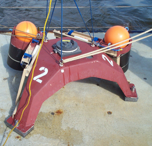 Back to Top SAX04 Update: 14 Nov 2004 From: Thomas Herbers Just a quick update on our recovery cruise on the R/V Pelican: We have so far recovered all instruments at sites 3, 4, 5, 6, and 7 ( site locations). Right now we are working just offshore of Ft. Walton Beach trying to release floats acoustically at sites 8, 9, and 1. So far we have had no luck with this and it is too rough to send divers down. We will go to site 2 later this afternoon. Still left to be done is the recovery of the Datawell buoy at site 9 and (as soon as conditions permit) diving operations to try to locate (and attach recovery lines) to missing tripods.That's it for now; I will send out a more detailed update soon. Back to Top SAX04 Update: 9 Nov 2004 From: Eric Thorsos Cell: 206-890-3598 1. We are now nearing the end of all work on SAX04. The RVSJ offloaded APL-UW equipment at NSWC-PC today and will return to the SAX04 site overnight for recovery of the moorings on the 10th (and the 11th, if necessary). Work continues on the R/V Pelican with the Hanes/Traykovski groups now at the site. This will be followed by the Herbers group over the 12–16 Nov period. A cold front passed through the area during 1–2 Nov, increasing the wind and wave heights. The RVSJ left the moor on the afternoon of the 1st and was back on site the morning of the 3rd. This weather event resulted in a new ripple field at the site with substantial ripple heights. NSWC-PC is tentatively scheduled to carry out a SAS survey of the site this Friday or Saturday (12 or 13 Nov). The survey will attempt to detect buried and partially buried mine shapes, with propagation mainly at subcritical grazing angles. The new ripple field will likely improve subcritical penetration for this survey. (A related "BOSS" survey, just completed, is described in item 12.) In spite of our problems with Hurricane Ivan and other weather events, a vast amount of high quality acoustic data has been gathered, supported by extensive environmental measurements. The potential for scientific advance appears to be at least as high as for SAX99. The sections that follow summarize the work since the last Update. 2. Chris deMoustier and the NAVO team carried out a multibeam bathymetry survey of the SAX04 site and nearby regions on 25–28 Oct, including the Todd Holland tower site to the west. NAVO's Bertram was brought well inside the RVSJ mooring buoys to cover the entire region near the ship. Kevin Williams and I made a brief visit to the NAVO vessel on the evening of 27 Oct, and picked up a bathymetry map of the site at a 1-m pixel resolution. At this resolution, most features shown near the RVSJ were identifiable as deployed equipment. Later processed results are to include bathymetry at 0.25-m resolution and (I believe) scattering strength maps that would show regions of mud and sand. 3. At the time of the last Update, work had begun on moving the APL-UW 30-m rail system 30 m to the east, allowing SAS measurements to be made on the original flush buried field. This move was completed and a series of SAS runs were made. Images were obtained on two 14-in fluid filled steel spheres that divers had buried in the field the previous week. Better images were obtained on a partially buried Mk 36 that had been imaged with the previous rail position. An image was also obtained at the position of a target mentioned in previous Updates that had a light line to the surface. Since this detection was made only at higher frequency bands (30ל50 kHz and 60–100 kHz), it is not clear at this point if the target or sediment structure above the target produced the feature detected. Following the SAS runs, the rail tower was lowered into the mode for backscatter and forward scatter data taking. Forward scatter runs were made at 10–100 kHz and backscatter runs were made at 10–150 kHz. Next, sediment manipulation studies were done at the rail system site in collaboration with NRL. A marble patch was constructed and backscattering measurements were made for several marble concentrations. Finally, bistatic scattering data were taken at 3 kHz using a rail tower source and a fixed receiver placed 10 m out from the rail and 8 m from one end. The goal was to look for effects of ripple scattering on the bistatic scatter angular distribution. 4. A second major APL-UW effort during this period was focused on a study of subcritical acoustic penetration to a 30-element buried array. Picking up from the previous Update (24 Oct, item 8), the data were collected at the 15-m range tower positions. Following this, measurements were repeated at the 7-m range tower positions after it was noticed that some data were clipped. The 20-m tower positions were then not done. Preliminary results show little subcritical penetration, consistent with the observation that there were no discernable ripples in the region near the buried array. An evanescent field was detected near the surface and found to become more prominent as the frequency decreased. Following the penetration measurements using a natural sediment, similar measurements were made after five separate sediment manipulations: (a) the sediment was smoothed by divers, (b) a collection of Tim Stanton's aluminum sand dollars were placed on the sediment surface, (c) a sinusoidal ripple with a 50-cm wavelength was formed by divers, (d) a sinusoidal ripple with a 75-cm wavelength was made, and (e) the sediment was smoothed and a single sand dollar was placed on it. For each of these cases, two tower positions separated by 90 deg in azimuth were used at both 7-m and 10-m ranges. For cases (c) and (d), the ripple was oriented so that the direction of the incident field, when projected onto the mean plane of the sediment, was either parallel or perpendicular to the ripple crests. The ripple height was about 5 cm peak-to-trough. The data for these measurements have yet to be analyzed. Data from the penetration array and from a separate HF attenuation array yield sediment sound speed and attenuation as a function of frequency. Initial results for both sound speed and attenuation appear consistent with results obtained during SAX99. That is, at the low frequency end, the trends with frequency are consistent with Biot model trends. On the other hand, the attenuation at high frequency increases faster with frequency than given by the Biot model. 5. Three sets of APL-UW IMP2 data were taken after 24 Oct. One was taken from a site near the penetration array (a site to which XBAMS had been moved), one was in the original flush buried target field near a target, and the last one was also in the original flush buried field at a position 10–15 m south of the rail, about in the middle of the rail in the E-W direction, with alignment perpendicular to the rail. These data will serve to (1) yield the ripple field near the 2nd XBAMS position to test ripple field inversion from XBAMS data, (2) assist identifying ripples near a buried target, and (3) provide ripple field data for bistatic scatter measurements (see item 3). 6. An experiment was done by DJ Tang using the RVSJ small boat (a Boston Whaler) as sound source. A single receiver was moored at a 6-m depth while the Whaler made north-south and east-west runs. For the east-west runs, the Whaler was at a 6-m depth. For the north-south runs, the depth varied from 2 m to 10 m. The goals of these measurements are two-fold. The first is to better understand sound propagation in a wedge environment; the second is to invert for bottom sound speed as a function of frequency between 500 Hz and 4 kHz. Preliminary processing of the data indicates that they are of promising quality. 7. DRDC Atlantic and ARL/PSU are using several different techniques to measure the sound speed dispersion at the SAX04 experimental site. On an earlier trip (11–14 Oct), directional receivers (pressure and 3 axis acceleration) and omni-directional projectors were buried in the seabed. After leaving these buried sources and receivers to settle for ten days, the DRDC-ARL/PSU experimental program ran from 24 Oct to 1 Nov. It began with the deployment of additional projectors and receivers in the water column, the pressure vessel with the acquisition system, and numerous cables. Of the 32 receiver channels, 7 vector sensors and 4 hydrophones, all but one remained operational for the duration of the experiment. Signal to noise quality was very good at frequencies above 1 kHz and appears sufficient below 1 kHz where the source level of the projectors employed and ship radiated noise were the limiting factors. Numerous ambient noise samples were also collected. Buried source time of flight measurements were made from 600 Hz to 38 kHz. Moored source angle of refraction measurements to the buried directional receivers were made from 600 Hz to 12 kHz. Reflection loss measurements, using the moored sources and omni-directional receivers in the water column, were made from 2 kHz to 18 kHz. Impedance/reflection/transmission measurements were made from 600 Hz to 18 kHz using a pair of directional receivers in the water column, directly above another of the pairs of directional receivers buried in the seabed. The three-point mooring system for the projectors in the water column worked very well. A haul-down line with a pulley system was used to adjust the length of one of the "legs" and control the grazing angle. Measurements were made at a total of 17 grazing angles, from 8 to 90 degrees, concentrated just above and just below the critical angle. Additional grazing angles around the critical angle were obtained using a projector hanging beneath a small catamaran. It was moved between the stern of the vessel and a clump anchor along a "clothesline" pulley system. The only experiment with disappointing results was the broadband impulsive source also mounted on the catamaran. The source level, lowered substantially from its typical level in order to comply with the environmental assessment, was not sufficient to overcome the ambient noise conditions. Recovery of equipment began on 3 Nov, but was hampered by poor visibility on the first day back after the weather event of 1–2 Nov. Visibility improved dramatically on 4 Nov, and the equipment recovery was completed on that day. 8. OSU efforts during the week of Oct. 24–31 focused on two activities: micro-resistivity profiling, and tracer deployments. Using an in situ resistivity profiler, data were collected at 3 sites: the SAX04 site (19 m in depth), a 14-m site, and a 10-m site adjacent to Peter Traykovski's tripod. There were substantial differences between the sites. At both the shallow sites, there were low amplitude (< 3 cm) ripples that had been bio-degraded. There was little evidence of mud at the 14-m site, whereas at the shallow site mud had accumulated in circular depressions (0.5 to 1 m diameter, up to 20 cm deep) that had a patchy distribution (i.e., the depressions were encountered on 2 of 3 dives within an area of roughly 150 m). At the SAX04 site we worked east of the RVSJ, where we encountered clearly defined ripples (~ 7 cm height, 70 cm wavelength) covering most of the seafloor. In addition, a roughly 15-m diameter mud patch was observed to the SE of the OSU buoy. Resisitivity profiles taken in troughs within the mud patch showed that the overlying sand was 1–3 cm thick and the mud was 2–5 cm thick. Preliminary (i.e., uncalibrated) porosity values in the mud layers ranged from 65 to 85%, depending on the thickness of the overlying sand (i.e., thick sand, lower porosity muds). In anticipation of returning to the study site in January (discussed next), replicate tracer patches were emplaced in and out of the mud patch. The tracers are SAX04 sand that has been labeled with trace quantities of silver. Later coring and enumeration via instrumental neutron activation will permit estimates of bioturbation intensity that has relevance to ripple degradation rates. Finally, we are exploring (with ONR and colleagues from the USGS) the possibility of deploying two autonomous tripods at the SAX04 site over the winter (January to March). Key sensors on the tripods would include an autonomous resistivity profiler that moves in 3 dimensions, a film-based stereocamera, a time-lapse optical device that measures grain size (the "poking eyeball"), a sector scanning sonar and a variety of water mass sensors (e.g., ADCPs, ADVs, CT sensors). If deployed these tripods would extend significantly our ability to track the SAX04 seabed as it evolves post-Ivan. 9. The NRL group has worked to the end of the main experiment period, continuing work described in previous Updates. The emphasis in the remarks that follow are on new areas of work. 24 Oct: Set up lab on shore to section cores for water content. 25 Oct: Started taking LF data for sound speed and attenuation. The equipment includes 30 buried hydrophones and 5 buried 3-axis accelerometers. Two buried sources were used at depths ranging over 0–100 cm. 26 Oct: 16 stereo photos taken along an E-W line 7 m south of the APL-UW rail. 27 Oct: Raking manipulations at the Dalpods. 28 Oct: The "little" ISSAMS was deloyed under the RVSJ and used to measure compressional and shear speeds and attenuations. Three deployments were made over several days; the other two to the north of the RVSJ, one forward, one aft. 29 Oct: Manipulations at the APL-UW rail: Marbles were laid on the sediment for scattering studies and then added to make three different concentrations. 30 Oct: Began in situ resin impregnation work on the seafloor. There were 5 deployments in total, two at the NRL LF site, two off the starboard side of the RVSJ, and one at the Dalpod 1 site. On this day visibility was reported to be 50 feet. The resin impregnation units were recovered on 7–8 Nov. A few general observations made before the most recent ripple field formation: As time passed the ripples became more and more subtle around the ship. Right after Ivan there was little bioturbation, little evidence of fauna on the seafloor. The bioturbation gradually increased, and by the end there was much more bioturbation, much more reworking, leading to rapid ripple decay, at least near the ship. 10. Report from Alex Hay on the Dalhousie group work: The ripples formed during Tropical Storm Mathew have degenerated gradually with time, the variance in the 1 to 3 cycle/m band decreasing by an order of magnitude in a nine day period, from 3.5 x 10⁻⁴ m2 to 0.3 x 10⁻⁴ m2. Diver observations indicate a factor of 2 reduction in ripple height, from 6 to 3 cm, similar to the height changes observed in the acoustic profiles. The acoustic profiles indicate a gradient in the rate of ripple degradation with distance from the instrument pod, higher rates occurring under the pod. These higher rates are consistent with the impression we have so far that fish interactions with the bed are the primary ripple degradation mechanism at the SAX04 site. Experiments carried out with mounds of glass beads in collaboration with NRL, both at the Dalhousie pod and under the ship in the field of view of the stereo camera deployed by Eric Pouliquen (NURC) and Tony Lyons (ARL/PSU), yielded marked differences in the mound degradation rate. The mound under the ship had disappeared within less than 24 hours, while a mound of identical beads of the same volume at the Dalpod was still identifiable in the video images 5 days later. Experiments with artificial ripple of 4, 6, and 8 cm wavelength were carried out, again in collaboration with NRL. A second glass bead experiment was also carried out, with a larger mound. Sediment cores collected at the end of both this experiment and the first contain glass beads in varying amounts, some with quite sharp boundaries between the beads and the underlying sediments. 11. The continued improvement in the water column visibility allowed further stereo camera measurements for sediment roughness determination. The APL-UW stereo camera was used in the original deeply buried target field and to survey the sand above the buried array. These results will support modeling of the SAS results on the deep field and the penetration array results. The stereo measurements near the buried array were consistent with essentially no ripple at that site, consistent with earlier diver observations. The NURC stereo camera was used to take a time series near the buried array site. XBAMS (at its 2nd position) took 300 kHz backscattering data in the same region. The XBAMS data will be used to invert for the bottom roughness, and the NURC stereo camera results may provide ground truth for that effort. 12. Steve Schock's BOSS survey of the SAX04 site: On Thursday night (4 Nov) the RVSJ made its first equipment recovery trip to NSWC-PC for offloading on 5–6 Nov. Steve Schock and his group arrived at the SAX04 site on the Pelican on the 4th and conducted surveys of the target field and nearby areas from Thursday evening until late Friday night. The BOSS survey yields image maps of subsurface structure using down-looking 3–19-kHz sonar. The results can also be processed to show 3-D views of the structure in selected regions, giving the depth of detected targets. The goal of the survey was to try to locate targets buried in May that had be moved by Ivan and remained missing. I was along for the survey and attempted to relate the observed image features with the many known objects at the target field site and then select unknown features for further investigation by divers. A BOSS survey can clearly provide useful information on buried objects. For example, a known buried target that was 20–30 cm below the surface showed up in the 3-D image as a strong target close to the surface as expected. But at present it is not clear how to distinguish a target of interest from other sediment features, such as small mud patches, that may show up in images (an area of needed research!). I worked with Kevin Williams to come up with a set of six dives to further investigate subsurface features, though three of these were actually revisits to sites where targets had already been located by probing. We felt the revisits were needed to further clarify the nature of these targets. Of the three remaining sites, one turned out to contain a screw anchor on the sediment surface. At another, a localized hard patch was located about 2.5 feet down that could be broken through with a probing rod with sufficient effort; we suspect this was a localized, dense shell patch. At a third site, nothing could be found even though the divers probed over a wide area. We suspect the BOSS image in this case showed a small subsurface mud patch, but that is just an hypothesis. Unfortunately, it does not appear that any of the missing targets remain on the two target fields. Hopefully, the NSWC-PC SAS survey, which can cover a wider area, might yet locate some of the missing targets. Back to Top SAX04 Update: 24 Oct 2004 From: Eric Thorsos Cell: 206-890-3598 1. At the time of the previous Update (12 Oct), we had just returned to the SAX04 site after a modest weather event associated with Tropical Storm Mathew. The visibility in the water column then was very poor, even though the mud previously overlying the sand was absent. Starting the next day, and continuing to the present, the visibility has been very much improved. At times the visibility has been up to 25–30 ft, while at other times it might be more like 6–10 ft. Even so, the visibility is now essentially always better than it had been prior to our return to the site on 12 Oct. 2. It has now become clear that while some of the mud overlying the sand may have washed away, much of it was simply covered over with new sand. At the risk of oversimplification, it appears that regions that previously had thick mud deposits now have thick mud deposits under a relatively thin sand layer. Regions that had thin mud deposits now appear as relatively firm sand. This change has no doubt contributed to the improved visibility. The reduced amount of suspended mud has not ended all visibility problems because near the bottom there is often significant "sea snow," dense collections of mucus globules and strings that rain down on the sediment surface. The sea snow has often been a limiting factor preventing the application of stereo-photography. 3. The following report came from Chris deMoustier on 18 Oct: The Coast Guard Station, Destin FL, has no power or fuel to offer, but Doug Cronin managed to get permission to park NAVO's Bertram there at night during our survey work. Yes, we shall start round 2 of the multibeam bathymetry surveys on Monday October 25th, and run for 4 days as budgeted. (Thank you Doug) We can no longer call this an event response (5.5 weeks later), but we do expect to see some changes relative to the pre-Ivan conditions surveyed at the beginning September. Now is the time to decide when the next two budgeted surveys should take place. What would make sense for the science program? Would surveys at six weeks intervals post-Ivan be worthwhile? That would place survey #3 in mid-December (e.g. the week of Dec 13th), and survey #4 at the beginning of February 2005 (e.g. week of Jan 31st). Please let us know whether this tentative schedule works for you all. (End of report.) The immediate reaction here on the RVSJ was that surveys in December and beyond would not be particularly relevant to the work presently ongoing. The most desirable time for another survey would be immediately following the end of activity at the site. That would suggest the week of 15 Nov for the next survey. However, there are some valid reasons for later surveys. Todd Holland replied on 19 Oct to the email by Chris as follows: From my perspective, the six week interval would be preferable. Our video camera system in the tower has been without power since Ivan such that we did not get much overlapping data with the SAX experiments. Having a longer survey period (till the end of January) would increase the overlap. Of course, that would be relative to the tower region, so I suspect that another option would be to conduct the third survey soon after the second survey to cover some spatial (not temporal) regions that were missed due to Ivan. (End of reply.) Later surveys might also be of interest to anyone attempting to model the ripple properties based on wind and wave field data from the National Weather Service. If you have input on this issue, please make your views known. 4. Work has continued on locating the targets buried in the target field in May and likely moved about by Ivan. When SAS runs were resumed after the weather event associated with TS Mathew, two targets that had previously been detected acoustically were no longer detected. The diver deployable metal detector was tested in water using a 14-inch metal sphere; the sphere was detectable to a range of only 18 inches. Divers then used the metal detector without success in an attempt to locate the two targets that were no longer detectable acoustically. One of these targets was later located by probing with rods; it was exactly at the position indicated by the original SAS images (pre-Mathew). The depth to the target was found to be 34 inches, too deep to be detected with the metal detector. It appears that a new sand layer was deposited over the target field during Mathew, increasing the target depths. The other target mentioned above has yet to be probed for. Another acoustic target at a range of 37 m from the APL-UW rail system was probed for and located: the depth was about 2 ft and it is likely to be a cement pipe, one of the clutter targets. Another acoustic target was located just to the east of the deeply buried field (and thus in the original flush buried field), but still close enough to the rail system to yield an image. Divers found a partially buried Mk 36 at this location. This target was originally buried in the flush-buried field and had been moved about 15 m by Ivan. A buried target in the flush buried field with a light line to the sediment surface was mentioned in the 12 Oct 2004 Update. Divers probed this target and found it to have a deep end at 1–2 ft depth and a shallow end at 6–8 in depth. 5. The tower that rides on the 30-m rail was folded down to its backscatter/forward scatter position on 16 Oct. This new configuration changed the balance of the tower, and some minor damage caused by TS Matthew then became more significant. This problem was overcome, but it took a major part of a day's worth of diving. Backscatter data were obtained over the range of 10–500 kHz at grazing angles of 10 deg to 40 deg. For each case the backscatter was obtained from about 100 independent patches on the bottom as the tower moved along the rail. Forward scatter data were obtained over 4–200 kHz for specular grazing angles of 60, 70, 80 and 85 deg. In each case about 80 independent surface patches were used. 6. On 20 Oct the rail tower was returned to its upright position for SAS measurements, this time for both monostatic and bistatic backscatter measurements from 3 proud mine shapes and 3 proud clutter targets. The backscatter measurements were made using sources on the rail tower. For the bistatic measurements, the NSWC-PC parametric source was used. Bistatic data were collected at 1–16 kHz using the secondary fields and at 56–72 kHz using the primary fields. In each case both the source and receiver heights were about 4 m and the range to the targets was about 10 m. 7. On 23 Oct work began on moving the 30-m rail system 30 m to the east; this will allow SAS measurements to be made on the original flush buried field. One of the four rail sections was moved to the new site and leveled. The rail tower was then moved onto that section. Work will continue on assembling the rail system at the new site on 24 Oct. APL-UW diving to date has required 380 nitrox tank fills. 8. A second major APL-UW effort has been ongoing during this period: preparation and operation of the system for studying subcritical acoustic penetration to a 30-element buried array. After returning to the SAX04 site on 12 Oct, the task of excavating and sinking the cofferdam to a depth of 60 cm was completed. Clean sand with little shell was encountered over about the first 50 cm, while the last 10 cm was sunk through a major concentration of shell hash. From the cofferdam, divers then inserted the 30 hydrophones to the array element positions in the sediment without disturbing the sediment above the array. The array element positions were then surveyed in using sources on the 5 m by 10 m frame. At this time there is no discernable ripple remaining in the region near the buried array. It appears that fish activity near the site (attracted by the presence of the frame) has been important in reducing the ripple height, since ripples are more evident away from the frame, though they do have low amplitude. Four acoustic sources are located on a diver movable tower, and the tower positions lie along arcs centered on the buried array with radii of 7, 10, 15, and 20 m. For the 7 m radius, the grazing angle is above the critical angle. For the 10 m radius, the grazing angle is near the critical angle, just above or below depending on the particular source. The larger radii yield subcritical grazing angles. Data have now been collected at the 7 and 10 m ranges. The 7 m range data show greater field penetration than found during SAX99, perhaps due to less scattering from shell. The 10 m range data have not been examined yet. The 15 m tower positions were surveyed in on 23 Oct, and will be used next. Data collection has also just begun with the APL-UW attenuation array, close to the buried array site. The site for the buried array was chosen to have firm sand. 9. The DRDC group was on the RVSJ from 11 to 15 Oct. During this period they (in conjunction with Tony Lyons, ARL-Penn State) deployed sensors in the seabed for a measurement program to begin after their return on 24 Oct. Here is a report by John Osler on their activity. Introduction: - The DRDC/ARL team is measuring sound speed dispersion in the 1–10 kHz frequency band. Four approaches are being pursued: a) Angle of refraction into the seabed using buried directional receivers; b) Acoustic impedance using pressure/velocity receivers in the seabed and in the water column; c) Reflection loss using sources and receivers in the water column; d) Time of flight measurements using receivers in the seabed in conjunction with sources in the seabed and in the water column. Tuesday, 12 October: -Briefed APL-UW divers on the operation of the DRDC/ARL burial jig. Wednesday, 13 October: - Test dive by APL-UW divers with the burial jig. Dummy sensors were inserted into the seabed and later extracted. - Experimental field laid out by APL-UW divers with sand screws and nylon ground lines (locations below). The ground lines were used the following day to position and orient the burial jig at the center of the experimental area. The sand screws will be used to moor acoustic projectors in the water column with a known geometry relative to the buried receivers. Thursday, 14 October: - Insertion of the TV-001 receivers and ITC-1032 sources into the seabed. Friday, 15 October: - Tests with an SX-100 broadband acoustic projector that will be moored in the water column. The source was tested at 1, 2, and 8 kHz at source levels of 160, 170, and 180 dB re 1 microPascal at 1m. Location information (based on position of sand screw A)
Background re the burial jig and receivers: The burial jig is designed to insert four receivers and two sources into the seabed at known depths, horizontal separations, and with known vertical and azimuthal orientations. The receivers are Wilcoxon TV-001 sensors that measure acceleration (3 axes) and pressure. The acceleration components can be used to determine the vertical and azimuthal angle of the acoustic arrival. The pressure and acceleration components can be used together to measure acoustic impedance or acoustic intensity. The buried sources, ITC-1032 spherical projectors, will be used to confirm the location and orientation of the receivers and in the time of flight measurements. 10. The NSWC-PC group came on board the RVSJ on 16 Oct and will depart 24 Oct. Here is a brief summary of their activity, supported by APL-UW divers:
Bottom backscattering strength nearly constant over 3–10 kHz, then higher at 20 kHz. All proud targets detected in backscatter over 1–20 kHz. Only mild enhancement noted in backscatter near 1 kHz due to ripple. On 20–21 Oct, Tony Mathews from NSWC-PC collected data related to underwater communications. The parametric source transmitted at 1–20 kHz and the signals were received at ranges of 1.5 and 2.5 nmi using another vessel (the "Reeldoc"). 11. The NRL group has continued an active diving schedule throughout the period. Manipulative experiments near the BAMS tower site ended on 7 Oct. After the RVSJ returned to the site on 12 Oct, marbles that had been laid out in a muddy area were found in a mud lay below a sand layer at the sediment surface. A collection of aluminum "sand dollars" had been set on edge into the mud for scattering experiments using BAMS. These were also found after 12 Oct in a buried mud layer below an overlying sand layer. When found, the aluminum sand dollars were laying flat, an artificial shell layer. Allen Reed has been impregnating cores with resin for later analysis. A mobile CT unit should be operating by 25 Oct near the Coast Guard Station just west of the Destin Inlet bridge. Dale Bibee and Mike Zimmer have been deploying sensors in a 4 m by 4 m region for LF sound speed measurements: the sensors include 35 hydrophones and 5 3-axis accelerometers at depths of 5–100 cm. Manipulation experiments continue at the Dalpod sites, and raking experiments have been conducted at the SAS rail site. Cores have been collected at sites where IMP2 has taken data, at the Scripps site (see item 17), and most recently in the target field area, since all rail measurements are now concluded in the deeply buried field. Also at the Scripps site, the salinity and viscosity of the pore fluid has been measured and found to be the same as for the overlying water. Thermal gradients in the sediment have also been measured. Divers report that collections of discarded shells are commonly found near sites that provide cover for octopi. 12. In addition to our exit from the 4-pt moor on 7 Oct (described in the previous Update of 12 Oct), we made another exit from the moor on the afternoon of 14 Oct due to rising wind and waves. This was a brief event, and the RVSJ returned to the moor on the morning of 15 Oct. During the time off the moor, the RVSJ stayed within a few miles of the site in order that the wave buoy data, which are being radioed to the RVSJ, could be collected. I recently checked with Tom Herbers, who reported that there was little if any loss of data during that period. 13. Report from Alex Hay: We have had two distinct upwelling events, one on 13–14 October leading up to the disconnect from the moor, the second on 15–16 October, 15–20 cm/s eastward currents being produced at about 1 m height above bottom in both cases. The Dalhousie team has continued to study the decay of the ripples generated during Mathew, which have exhibited a slow and steady decline in the variance of the primary 1–4 cycle/m band in the bed elevation spectrum. Since October 16 we have been taking advantage of the relatively quiescent conditions to carry out seabed manipulation experiments in collaboration with NRL, and in particular studies of the scale-dependent decay of manually-generated ripples. The high-resolution bed elevation profiles from the laser system and the associated video imagery have been a source of continuing fascination. Thus far, much of the disturbance of the bed, including the decay of natural and artificial ripples, would appear on the basis of our preliminary results to be associated with fish activity. In some instances when a fish is burrowing into the sediment a cloud of dark material is released from the bottom. This material is not sand, and seems likely on the basis of the diver-collected cores to be buried mud. Flocculated fine sediment continues to be a dominant feature of the nearbed water column and the sediment surface at the Dalpod 1 site. Flocs in suspension are prominent in the video imagery, both night and day, and form a very patchy fluff layer at the bed. The fluff accumulates in depressions (e.g. ripple troughs, fish feeding pits, etc.), and is wafted to and fro by wave orbital motion. Could the fluff layer dragging over the sediment surface contribute to ripple decay? All sensors on the two Dalpods have continued to operate satisfactorily. Data analysis is progressing well. Ryan Mulligan arrived from Dalhousie on Oct 18, and has been providing very useful assistance on the data analysis front. (End of report.) 14. Measurements have continued with the APL-UW IMP2 system. Five more sets of IMP2 data have been taken, three from the region off the stern of the RVSJ near the former ARL-UT site, one from along the SW mooring line 20 m from the RVSJ, and one from the buried target field. While the standard deviation of the roughness in these data sets has declined from the pre-Mathew value of 1.5 cm to just less than 1 cm, the power spectra at spatial wavelengths between 3 cm and 25 cm have made no appreciable change. This indicates that the variation in ripple height and wavelength has no direct impact on small-scale variations of bottom roughness. 15. The improved visibility has allowed stereo-photography to get underway at the SAX04 site. Eric Pouliquen has been working with Tony Lyons with the NURC stereo-camera system. After the camera system was recalibrated on 20 Oct with the camera's standard long legs in place, the long legs were replaced by short legs to reduce the impact of sea snow on stereo processing. A 2-day time series was recorded from the night of 20 Oct to the night of 22 Oct. The time series shows a daily cycle in roughness change, with the most rapid change at dawn and dusk. The pictures taken by the camera include glimpses of a sea turtle, sharks, rays, flounders, and remoras. 16. Chris Jones and Todd Hefner have been working with the APL-UW stereo-camera on ways to overcome effects of sea snow. This camera can take pictures at 1-s intervals, and intensity averaging 10 pictures is found to reduce significantly the effects of sea snow. The APL-UW camera system will focus on spatial variability, while the NURC camera will focus on time series. One series of 22 stereo pairs (each pair a ten picture intensity average) was taken as divers moved the camera along a 30-m track. About half of these are considered good, the rest have drifting fluff or mud that reduces the quality even when averaged. To facilitate the study of spatial variability, experiments are being made with small boat deployments of the camera where no divers would be required. 17. Mike Buckingham and his group from Scripps were at the SAX04 site over the 14–19 Oct period. A VLA in the water column and a buried array in the sediment were deployed at 30 deg 23.150 min N, 86 deg 38.601 min W. Light plane overflights of the VLA were made on 17–18 Oct. The propeller noise provides a very convenient noise source and the end result is that properties of the sediment can be inferred. 18. Finally, on 18 Oct, we had a group of distinguished visitors to the RVSJ via the shuttle: Ellen Livingston, Bob Headrick, Kerry Commander, all of ONR, and Jeff Simmen of APL-UW. Back to Top SAX04 Update: 12 Oct 2004 From: Eric Thorsos Cell: 206-890-3598 Since the previous Update of 3 Oct, acoustic measurements on the APL-UW rail system began in earnest, ARL-UT concluded work, and the groups from NRL and Dalhousie continued their ongoing measurement programs. Poor visibility has continued to be a major problem hampering work. Winds and seas began to rise near the middle of last week, forcing the RVSJ to come out of its 4-pt moor on Thursday morning (7 Oct). We were at NSWC-PC from Thursday evening through our scheduled loading period on Monday (11 Oct), and transited back to the SAX04 site overnight to begin work again on Tuesday, 12 Oct. Unsuitable wind and seas continued at the SAX04 site throughout our stay at NSWC-PC. DRDC, NSWC-PC, and additional NRL equipment was loaded during our period dockside; the DRDC group is now on board and will be replaced by the NSWC-PC group on 15 Oct via the shuttle from Destin. Upon returning to the SAX04 site today we found the mud that had covered much of the sandy substrate is now absent in most places checked by divers. In addition, a well-defined set of ripples is present; at Dalpod 1 the ripple wavelength was measured to be 50–60 cm, and the peak-to-trough height was measured to be 5–6 cm. While the mud from much of the bottom is gone, it remains in the water column and visibility today was very poor. Even so, major progress appears to have been made with regard to clearing out the mud deposited by Hurricane Ivan. Please note: The morning departure time for the shuttle from Destin to the RVSJ is 7:00. The afternoon departure time is about 16:15 with a goal of reaching the RVSJ at about 17:00. In the sections below, a description is given first for the 3–7 Oct period, followed by a summary of activity for 12 Oct. Activity over 3–7 Oct: 1. As described previously, two sets of 15 acoustic targets were buried at the SAX04 site in May. For one set, the targets were buried with their tops 30 cm down from the mean sediment surface, and the targets in the other set were flush buried. Hurricane Ivan's 40–50 ft waves (in the deeper waters offshore from the target field site) raise questions about the status of the buried targets. In the worst case, they could have all been moved from the site. Or, in another bad scenario, the targets could now be buried much deeper than before, making detection much more difficult. In the best case scenario the targets remain as originally placed. Our 30-m rail system was set up just inshore from the deeply buried field, and we now are beginning to obtain information on that target field. In addition, part of a third set of targets (including clutter targets) has been deployed on the sediment surface, that is, deployed proud. The SAS images do show several targets (in addition to the known proud targets), but the target positions generally do not coincide with their original positions. One SAS target was investigated by divers and found to be the 5-ft long cylindrical target originally buried to a 30-cm depth. Part of one end of that target was found to be above the sediment surface while the other end was below the surface. The target also was moved a few meters from its original position. This is the largest and heaviest target buried, and since it moved, it is likely that most if not all targets are at new locations at unknown depths. A light line connected to another target was noticed by divers in the flush buried field; a quick investigation showed this target to be deeper than could be readily determined by the divers without probing rods. It appears from acoustic results that some other targets shown in SAS images are also buried, but a definitive investigation has yet to be done. An NRL diver deployable metal detector was received on the RVSJ via the shuttle (thanks to Peter Traykovski) for use in tracking down acoustically detected targets, but we were not able to use it before the RVSJ left the moor. The SAS images of targets are obtained using chirp pulses in various frequency bands. The bands at 6–10 kHz, 12–28 kHz, and 30–50 kHz have been examined the most to date. A target that shows up at the lower two bands but not at the third is likely buried, and this is the case for some targets. In general, the 12–28 kHz band gives much better SNR than the other two bands for the targets in the region where targets were initially buried 30 cm deep. The 30-m rail system will need to be moved by divers, a major effort, before images can be obtained in the region where targets were initially flush buried. 2. In other APL-UW work, equipment was deployed for low grazing angle penetration studies, as done during SAX99. A 5-m by 5-m frame and the cofferdam were deployed, and work began on sinking the cofferdam and on excavating the sediment within it. The cofferdam will be used by divers to deploy a buried array without disturbing the sediment surface above the array. The diver movable source tower used with the buried array was also deployed. Data were also collected on the size distribution of shell fragments for volume scattering modeling. 3. The APL-UW IMP2 system was deployed three times, all in an area about 20 m south of the RVSJ. IMP2 measures the depth dependence of electrical conductivity (from which porosity can be inferred) in 1-mm steps along a 4-m track at points with 1-cm horizontal separation. For one case the measurements were made parallel to the ripple crests, and for the other two the measurements were made perpendicular. All three data sets show partial mud coverage over sandy ripples. The thickness of the mud varies from 5 cm to essentially no mud covering. The sand ripples do not have a dominant wavelength, but all peak-to-peak separations are in the 40–70-cm range. In all three deployments sand pockets are found trapped in the mud layer overlying the sand ripples. The thickness of the trapped sand is about 0.5–1.0 cm. Kevin Briggs and Chad Vaughan of NRL collected cores at the same location where IMP2 data had been collected for two of the deployments. In each case, a set of four cores was obtained. The locations of the cores were selected based on the IMP2 data in order to verify three cases: (1) mud overlaying sand, (2) mud overlaying sand with trapped sand in the mud, and (3) no mud. An initial examination shows very good correspondence between IMP2 and all cores in terms of the existence of mud and trapped sand. Kevin Briggs has also obtained the sound speed and the attenuation coefficient at 400 kHz for some of these cores. 4. The ARL-UT group completed their site prep on 1 Oct. Cores showed that the site had a 1/2 inch mud layer over a sand/mud laminate. The ARL site consisted of a 3-m vertical array, a 1-m array buried at a 15-degree angle, and an optical navigational array. The source for the measurements and a backscatter receiver were mounted on an ROV. The ROV was deployed to take acoustic data on 2 Oct. ROV navigation proved difficult because of the low visibility and strong currents. Optical navigation of the ROV was impossible because at times not even the ROV frame (6 inches from the camera) could be seen. An acoustic tracking program was therefore developed to determine the position of the ROV. After the navigation problems were addressed, bistatic, monostatic, and transmission measurements were conducted in the 4.5–50-kHz band from 2–6 Oct. Additionally, the X-Ray Attenuation Measurement System (XRAM) was deployed to measure the depth dependent density in situ. Cores were collected from the XRAM deployment site for calibration purposes. Because of the poor visibility, no laser line scan data were taken. On 7 Oct, the RVSJ came out of the 4-point moor and the ARL-UT site equipment was left in place for recovery the following week. 5. The NRL group continued with a variety of investigations. The scattering work near the BAMS tower was completed. Sets of marbles and aluminum "sand dollars" were placed in the field of view of the BAMS projector for scattering studies. No sets of shells or real sand dollars were used because of their scarcity. Scattering from raked roughness was obtained over a variety of time scales, tine spacing, and azimuthal orientations of the roughness. Studies of raked roughness have continued near Dalpod 1 to examine the scale dependence of biological ripple degradation. A manual roughness system has been used to obtain 1-D roughness profiles for both the mud surface and the underlying sand surface. Cores have been collected for comparison with IMP2 (item 3), for volume scattering studies by Ivakin, and near BAMS to support the BAMS scattering work. A series of permeability cores has also been collected. For the cores clear of mud, the permeability is similar to that found during SAX99. Considering all cores, there is more variability in permeability than for SAX99 due to the effects of mud in some cores. Sound speed and attenuation has been measured at 400 kHz for many of the cores. The sound speed appears to be decreasing slowly with time since Hurricane Ivan, now about 1780 m/s compared to about 1800 m/s shortly after Ivan. The attenuation is found to be very low, which may be due to the well-sorted nature of the sediments and the lack of embedded shell fragments. 6. Dalhousie group results show that currents continue to exhibit pronounced vertical structure, suggesting the importance of baroclinic effects. Also, a pronounced front has been observed several days in succession propagating westward passed the RVSJ. Sediment manipulation experiments have continued near Dalpod 1 (mentioned in item 5). A fluff layer on the bottom is a continuing problem for optical imaging. Preliminary analysis of the acoustic imaging data is yielding promising results. Rms bed roughness and bed roughness spectra exhibit decay during the one-week period following passage of Tropical Storm Jeanne, and growth during the initial phase of the recent storm up to the time of disconnect. 7. Early in the period the NURC stereo-camera was moved to a site that appeared to have less overlying mud. However, some mud was still present, and more importantly, the visibility was not sufficient for stereo-photo analysis. 8. Another site survey by the Mayer group (in this case, being organized by Chris de Moustier) following Hurricane Ivan continues to be on hold. The Destin Coast Guard Station, used before as berthing for the multibeam survey, has been pressed into service to support other needs with higher priority (e.g., berthing for FEMA and other Coast Guard vessels), and it remains out of reach for our needs. Alternate berthing near Destin has not yet been possible to arrange. Activity on 12 Oct: 9. Because visibility has made stereo-photo measurements of roughness nearly impossible, we stopped at a site well offshore where visibility conditions were expected to be much better [based on the report by Dan Hanes in the SAX04 Update of 3 Oct (item 12)]. The site chosen was at 30 deg 13.3 min N, 86 deg 40.0 min W, about 10 nautical miles S of the RVSJ mooring position. The depth at the site is 84 ft. Both Eric Pouliquen from NURC and Todd Hefner from APL-UW obtained a set of stereo-photos from the sandy sediment at this site. While the conditions are not the same as at the SAX04 site, we still believe the results may be useful in verifying the break in the power-law roughness spectrum for sand sediments obtained by Kevin Briggs during SAX99. 10. The RVSJ went into the 4-pt moor and all cables were recovered without incident, though the visibility was very poor. As mentioned above, the mud previously overlying the sand is now absent, and a prominent set of ripples is now present. After reconnecting today, all instruments on the two Dalpods were found to be fully operational, and routine data collection has resumed. Work began on recovering the ARL-UT equipment left on the bottom the previous week, and should be completed on 13 Oct. The APL rail system was moved by wave action during the high seas event, and the tower has been partially derailed from the track. It appears that no fundamental damage has been done to the system, and at this point we expect to be able to resume operation relatively soon. The new state of the target field is presently unknown. Back to Top SAX04 Update: 4 Oct 2004 From: Eric Thorsos Cell: 206-890-3598 The item below is from Tom Herbers on 28 Sept; I intended to include it in the 3 Oct 2004 Update. Message from Tom Herbers: Just a quick update on the wave buoy. It is working fine now and the data is coming in on the CDIP web site. If you click on this site, click on the "Recent" tab, which will list a list of stations including 129 Fort Walton Beach, FL. Just click on this station and it comes up with a menu with various data displays (spectra, time series, tables, etc). Complete data can be downloaded directly from this web page. Back to Top SAX04 Update: 3 Oct 2004 From: Eric Thorsos Cell: 206-890-3598 Considerable progress has been made since the last Update of 25 Sept. During this period the Hanes/Trakovski groups completed Leg 5 of the Sept R/V Pelican cruise and the Pelican departed for its home base on 29 Sept. The RVSJ settled into a 4-pt moor and work began in several areas. Activity on the RVSJ will be described first, followed by the Pelican activity. 1. Both ships arrived at the SAX04 site early on 25 Sept. The RVSJ went into a 4-pt moor in the morning without difficulty. Visibility in the water was poor. The first APL-UW goal was to locate the clump anchor marking the NW corner of the 60 m by 60 m target field. Each corner has a 2000-lb clump anchor, a concrete cube 30 inches on a side deployed during target burial in May. The NW clump could not be located on the first or second dives, but on the second dive a log was encountered in the region close to the expected location of the clump. On the third dive the clump was found to be nearly flush buried, a result of Hurricane Ivan. There were further APL-UW dives, but poor visibility severely limited progress. The ARL-UT group did one dive but did not deploy equipment due to uncertainty related to Hurricane Jeanne (see item 2). The NRL group made some progress with dives near the Dalpod 1 site and BAMS. 2. This rather slow start was interrupted by uncertainty in the projected track for Hurricane Jeanne. Because a 4-pt moor does not mix well with tropical storm winds, the RVSJ came out of the moor late in the afternoon on 25 Sept and overnight moved west to a position off Mobile. The Pelican stayed near the SAX04 site and was able to work through the increased winds at the western fringes of H. Jeanne. 3. The shuttle vessel (the Aquanaut) began twice daily trips from Destin to the SAX04 site on the morning of 25 Sept and has been typically carrying 2–4 passengers on each of these trips. The shuttle concept has worked out well so far. 4. The RVSJ returned to the SAX04 site on 27 Sept, but the winds had not fully settled down, and the moor was not attained until the morning of 28 Sept. During the period from 27 Sept to the present, considerable progress has been made. The visibility has improved, and at times has been quite good, even near the bottom. More typically, the visibility has been acceptable from the surface to within 5 to 10 feet from the bottom, and much more limited in the region near the bottom. 5. The APL-UW group has concentrated on preparing for SAS measurements with the 30-m rail system. The four rail sections were assembled along the northern boundary of the target field box, and the tower that moves on the rail was deployed on 1 Oct. Initial acoustic measurements were begun on 2 Oct. The IMP2 system has also been used to measure the bottom roughness profile along 1-D 4-m tracks. IMP2 obtains the profile for the silt/mud upper sediment surface as well as the profile for the sand interface underneath. APL-UW diving activity has been intense. For example, on 2 Oct there were 9 APL-UW dives, each dive involving 2–4 divers. The "doughnut" (a floating platform with a battery powered winch) borrowed from NSWC-PC has been very useful for moving equipment in the water. 6. The NRL group has been conducting 4 dives each day, with 2 divers on each dive. This work has been at the BAMS, XBAMS, and Dalpod sites. A variety of tasks are being performed: setting up test areas around the BAMS tower for studying scattering from artificial ripples, marbles, shells, and sand dollars; taking sediment cores to determine sound speed, density, permeability, and other sediment properties; and making roughness measurements. The sand sound speed at 400 kHz is found to be about 1800 m/s. The mud/silt sound speed is close to that for water. 7. The dive team for the ARL-UT group has prepared their site off the stern of the RVSJ, and on 2 Oct acoustic measurements from the ARL ROV were begun. 8. The Dalhousie group connected power and signal cables from the RVSJ to the two Dalpod units deployed earlier from the Pelican. Data collection started on 28 Sept, and has continued around the clock since. The ADCP results to date (beginning 29 Sept) indicate that the low frequency currents are dominated by a semi-diurnal internal tide, with maximum near bottom speeds of order 10 cm/s. 9. The delivery of the NURC stereo-camera system had been delayed by various hurricanes, and did not arrive in time for the RVSJ departure from NSWC-PC. The equipment was trucked from NSWC-PC to Destin on 29 Sept (courtesy of NSWC-PC) and brought out to the RVSJ on the shuttle that day. The camera system has been assembled, calibrated, and is now deployed on the bottom next to the RVSJ. At present, it is deployed in a region with mud/silt on the surface, making stereo operation difficult. Plans are to select a site with a minimum of mud or silt at the first opportunity. 10. Near the RVSJ and the target field sites, the bottom has a mud or silt layer of variable depth overlying the sand underneath. In regions with considerable diving activity near the bottom, this top layer has been largely eliminated (blown away) exposing the sand underneath. In some other areas, such as near BAMS, the mud or silt has covered over the sand producing a nearly flat surface and showing little evidence of the rippled sand interface that lies underneath. In fact, IMP2 profiles appear to show that the rather sharply peaked ripple crests of freshly produced ripples are being preserved under the mud/silt layer where it is sufficiently deep. 11. In the 25 Sept Update I reported on NRL side-scan results in the region offshore from the Holland tower site. My report indicated that objects were observed on the bottom with prominent acoustic shadows. Having now seen the side scan results directly, I would say the shadows were not as prominent as previously suggested, and the returns from the bottom appear consistent with debris laying on the bottom. 12. Finally, Dan Hanes prepared the following report on Leg 5 of the Pelican cruise: The USGS-UF and WHOI conducted Pelican leg 5 Sept 24–29, 2004. WHOI collected sidescan sonar data from the 4-m water isobath to the 50-m isobath. We surveyed inshore of the "box" from 7- to 12-m water depth and to the east to about 19-m water depth. Inshore of the box we saw ~25-cm wavelength ripples with ~3–5-cm height. As we got out 10- to 12-m water depth a substantial number of 3- to 5-m diameter dark patches were visible in the sidescan data, these are possibly mud patches. They were less noticeable inshore in 7- to 10-m depths, and absent in 4- to 7-m depths. To the east of the "box" in 16–18-m water depth, we saw ~75-cm wavelength ripples and transitions from muddy areas with no ripples to rippled areas. These transitions were associated with the ridge and swale topography that can be seen on bathymetric charts. On the final day of the survey, we went offshore to 50-m water depth to examine the spatial extent of ripples from hurricane Ivan. We observed well defined ripples from 50- to 30-m water depth. In depths of approximately 20–25 m, a second set of ridge and swale features exist that have similar sand-mud transitions to the features at 19–22 m. Based on our survey we deployed our tripod at 30 23.530 N 86 38.649 W in approximately 9.5 m water depth. It extends 2.2 m above the seafloor and is NOT marked with a surface float. It will be recovered in early November. The USGS-UF obtained measurements of ripples and sediment size using optical and acoustical methods at approximately 50 locations. Five grab samples were also obtained. Site locations were guided in part from the WHOI REMUS surveys. The main transects were cross-shore from 5 to 40 m depth (approximately at 86 38W from 30 23.6 to 30 6.4N), and longshore (approximately 30 22.8N from 86 38.1 to 86 39.4W) in 18 to 20 m depth. Drops were also made at the peak and valley of a few of the ridge and swale features. Fine sediment and other material were generally found in the water column and also on the seabed. The amount of fine material on the seabed was highly variable, at some locations consisting of a layer less than 1 mm, and other locations several cm. Patches with thick mud deposits were generally flat, but regions with sand-shell and thin mud deposits were generally rippled, including the deepest sites measured. At 40 m depth the seabed consisted mainly of sand and shell hash, with well defined ripples. Back to Top SAX04 Update: 25 Sept 2004 From: Eric Thorsos Cell: 206-890-3598 1. On 21 Sept (Tues) the two Dalhousie pods were deployed from the R/V Pelican at positions just to the east of the large box formed by the RVSJ mooring buoys / clump weights. The coordinates are: Dalpod 1: 30 deg 23.225 min N, 86 deg 38.556 min W Dalpod 2: 30 deg 23.201 min N, 86 deg 38.547 min W These positions have red marker buoys. The NRL divers found the visibility workable and oriented Dalpod 1 with respect to shore. Cores were collected near the Dalpod 1 site, and the sand sediment did not have a surficial mud layer. However, the sand was soft and appeared to have high porosity. Surprisingly, when sound speed was measured later, it was 1770–1800 m/s (corrected to in situ condition), higher than for SAX99. 2. The RVSJ reached the SAX04 site late in the afternoon on 21 Sept with a load of four rail sections plus the three large targets that will be deployed proud. IMP2 had to be left at the dock in NSWC-PC because of a lack of deck space with the four rail sections on board. There was not sufficient daylight left to go into a 4-pt moor on the 21st. 3. During the following night hours, the NRL completed a second side-scan survey of the region offshore from the Todd Holland tower site, which is to the west of the SAX04 site. The side-scan images showed that in relatively shallow water with depths about 20 ft the sand had been eroded significantly, exposing a field of objects that presented acoustic shadows. It will require future dives to clarify the identity of these objects that project upward. (One speculation is that they may be tree stumps preserved from ice age times.) 4. For much of the day on 22 Sept the wind was in the 20–25 knot range from the east (or slightly south of east). The dynamic positioning (DP) system on the RVSJ could not hold position under these conditions, preventing a move into a 4-pt moor and/or deployment of the rail sections. Fortunately, the wind eased late in the day. We chose to hold to schedule by not going into the moor and simply setting the rail sections on the bottom near the ultimate mooring position for the RVSJ. There are no buoys marking the rail section positions. The three large targets were then set on the bottom just to the south of the 60 m by 60 m target field box. The position is marked by a single buoy at 30 deg 23.167 min N, 86 deg 38.644 min W. With the RVSJ dynamic positioning system, there appears to be no significant difference between desired and actual coordinates when deploying equipment. After these deployments, the RVSJ returned overnight to NSWC-PC. 5. On 22 Sept NRL diver cores in ripple troughs at the Dalpod 2 site showed mud layers up to 10–15 cm thick on top of the sand. Some cores at ripple crests had no mud layer at all. Some evidence of a thin sand layer forming on top of the mud was also observed. Side scan lines were run in the region around the target field box showing large-scale (10s to 100s of meters) patchiness on the sediment, with some sections appearing to have mud on the surface and other sections appearing to not have mud. 6. The wind and waves on 22 Sept appeared to cause a worsening of the visibility in the water column, a regression from the modest improvements that had already occurred. Ricky Ray and Mike Richardson (NRL) dove near the BAMS tower on 23 Sept and found the visibility too poor to work. Twenty grab samples, spanning depths from 5 m to 22 m, were taken at the site (west of the SWAX04 site) near the tower where Todd Holland has his equipment mounted. Two more side scan lines were also run at the tower site, one from shore outward, and one in the opposite direction. The Pelican began a transit to NSWC-PC at the end of the day on the 23th. 7. The RVSJ was at NSWC-PC during 23–24 Sept for loading. We realized even before reaching NSWC-PC that we could not load all the remaining equipment for one final trip to the SAX04 site. Our solution is to make an extra trip back to NSWC-PC on the night of 10–11 Oct and then on 11 Oct to offload the ARL-UT equipment and load the DRDC and NSWC-PC equipment. During the 24–25 Sept loading period, the DRDC van was temporarily loaded to check out electrical connections and tie down procedures. APL-UW, ARL-UT, NRL, and Dalhousie equipment was loaded on the RVSJ. The antenna for receiving the wave buoy RF transmissions was also transferred from the Pelican to the RVSJ. The RVSJ departed for the SAX04 site at midnight on 24 Sept. 8. On 24 Sept the Hanes and Traykovski equipment was loaded on the Pelican for Leg 5. It was discovered several days previously that H. Ivan damaged the wave buoy, since the data being received were not good. Therefore, two members from the Herbers group also boarded the Pelican for Leg 5 with a replacement wave buoy. The Pelican departed from the NSWC-PC dock late in the afternoon on 24 Sept. 9. Chris de Moustier has been organizing the multibeam event response following H. Ivan. Chris sent the following report on 23 Sept: After speaking with Doug Cronin this afternoon, I can confirm that we'll start the second round of bathymetry surveys on Monday October 4th, 2004. This is a bit slow for an "event response", but that's the best we can muster given the logistical challenges. We plan to return to the site for round three of these surveys on Monday October 25th. Each iteration will take one week of surveying. Back to Top SAX04 Update: 20 Sept 2004 From: Eric Thorsos Cell: 206-890-3598 1. The Destin Village Inn now has power and is back in operation. In fact, the NRL group is staying there tonight, and will be picked up tomorrow morning by the Pelican as it arrives in the area to begin Leg 4. 2. The visibility at the SAX04 site has improved but is still poor, especially near the bottom. Rob Wheatcroft, working from the Pelican, reported that the turbidity was noticeably less in the top 40 ft, but below that it rose quickly and in the lowest 10 ft the visibility was so poor that he could not work effectively. APL-UW divers also made dives today, and reported similar conditions, but were able to accomplish some tasks on the bottom because visibility was less important for that work. 3. Rob measured porosity profiles in the top layer of the sediment and found a mud layer 1–2 cm thick (even thicker in the ripple troughs) at the water-sediment interface with porosity as high as 90%. 4. On Sunday the fourth RVSJ mooring was deployed as well as a clump anchor for later use by DRDC. Next, the APL-UW BAMS and XBAMS acoustic towers were deployed and should now be collecting backscattering data from the bottom in circular scans at 40 kHz (BAMS) and 300 kHz (XBAMS). BAMS does a 360 deg scan once every hour, while XBAMS does a 360 deg scan every 3 hours. Coordinates: BAMS: 30 deg 23.284 min N, 86 deg 38.496 min W XBAMS: 30 deg 23.203 min N, 86 deg 38.496 min W DRDC clump: 30 deg 23.232 min N, 86 deg 38.816 min W These are the target coordinates, but we believe the actual coordinates are very close. All three have marker buoys. For BAMS and XBAMS, the markers buoys are offset by about 10 m and are not attached to the towers. The RVSJ mooring buoys are large white metal spheres and are easily seen. Target coordinates for the buoys/clump weights: NW: 30 deg 23.297 min N, 86 deg 38.709 min W NE: 30 deg 23.297 min N, 86 deg 38.571 min W SW: 30 deg 23.189 min N, 86 deg 38.709 min W SE: 30 deg 23.189 min N, 86 deg 38.571 min W Target coordinates for the Danforth anchors outward from the clumps: NW: 30 deg 23.318 min N, 86 deg 38.729 min W NE: 30 deg 23.318 min N, 86 deg 38.551 min W SW: 30 deg 23.168 min N, 86 deg 38.729 min W SE: 30 deg 23.167 min N, 86 deg 38.552 min W 5. The APL-UW IMP2 system was also deployed on Sunday. IMP2 has a probe that measures the porosity as a function of depth at a set of points spaced 1 cm apart along a 4-m track. Today, divers oriented the track to be approximately perpendicular to the ripple crests and the first data set was taken. However, after hearing about Rob's findings regarding the thickness of the high porosity layer near the interface, it was realized that IMP2 needed to be reprogrammed to reliably capture both the layer and the sand interface below it. Thus, IMP2 was recovered today and is back on the RVSJ as we head for NSWC-PC. A quick look at the IMP2 results shows the newly formed ripple profile draped with a high porosity mud layer. 6. The Pelican left the SAX04 site early this afternoon, transited to NSWC-PC and arrived this evening. The Dalhousie equipment was then to be loaded, with the Pelican returning overnight to the SAX04 site, picking up the NRL group on the way in Destin. The OSU divers will continue their work and also be aboard. The Dalhousie pods will be deployed tomorrow. 7. The RVSJ left the SAX04 site this evening, and is transiting to NSWC-PC overnight. Four SAS rail sections have been assembled in the last few days and are ready for loading in the morning, along with the RVSJ mooring lines. We will return to the SAX04 site tomorrow and plan to go into a 4 pt moor, after the Dalhousie deployment has been completed. The rail sections (each 10 ft wide and 25 ft long) will be placed on the bottom on Wednesday. Back to Top SAX04 Update: 18 Sept 2004 From: Eric Thorsos Cell: 206-890-3598 Since some of you may be traveling to Panama City or Destin soon, I will try to give an overview of the present situation following Hurricane Ivan. 1. Panama City: When we drove through Panama City to NSWC-PC from the NE on 17 Sept, we found the region hardly affected by the storm. Businesses, restaurants, and hotels were open and the scene appeared nearly normal, though if one looks closely, signs of the storm are there. Power appears to be mostly restored, and very few trees are down. The damage in the PC area appears to be mainly confined to regions where tornadoes touched down (and perhaps right along the shore but I haven't been there.) NSWC-PC was open on Friday, and we could see no effects of H. Ivan at the base. The Hampton Inn, quite close to NSWC-PC (and where our group was staying), has no power and is closed because a tornado came through nearby, destroyed several buildings, and took out a number of power poles. 2. Destin: I was unable to make phone or cell phone contact to sites in Destin on 17 Sept, so I drove over in the afternoon to inspect. The situation there is quite different from Panama City. Power is mainly out, and most street lights are not operating. No businesses appeared to be open, but cars were allowed to drive the streets, which are basically clear. There is a curfew to keep drivers off the streets at night. Many signs, fences, roofs over gas station pumps, and similar light structures are down. But, most buildings appear intact with little or no damage. There is some roof damage here and there, but not much. More trees were affected than in Panama City, but still almost all made it through. The Destin Village Inn has no power and is closed, but has no damage that I could see. The boats that rode out the storm in Destin Harbor appeared to come through without obvious damage. Our shuttle vessel, the Aquanaut, was removed from Destin Harbor to a safer location, and I found out today (18 Sept) that it is fine. Cell phone service came back on in Destin on the 18th. On the route from the Destin Village Inn to the Aquanaut berth, the boardwalk was damaged but was being repaired with new planking while I was there. The sign on the Aquanaut berth was gone. In general, the situation was not as bad as I expected. When the power comes back, the area should return to near normal quickly. (Local radio reports, however, indicate that the damage is much worse in Pensacola and further west.) With conditions as they are right now in Destin, commuting to the RVSJ via the shuttle should not be a problem, but until the power returns in Destin one would probably need to be based in Panama City and commute by car to the shuttle in Destin. The National Guard stops the US 98 traffic from crossing the bridge onto Santa Rosa Island at the west end of Destin because the highway was extensively washed out along the island. The Coast Guard Station at Destin is just across the bridge, and the R/V Bertram operated out of a pier there for the recent multibeam and side scan surveys, and would presumably prefer to do the same for a multibeam event response survey. Chris de Moustier, who is organizing the event response, was interested in info on the station's status. Fortunately, a Sheriff's car appeared and I was able to get permission to cross over and visit the station. I met with George Young, who indicated that he was involved with arranging the support for the earlier surveys. While the building at the station appeared OK to me, one pier was lost and they have no power. George felt that next week was not likely to be appropriate for hosting the Bertram, but the following week would probably be OK. 3. Both the R/V Pelican and the R/V Seward Johnson transited to the SAX04 site last night. The Datawell wave buoy deployed prior to the hurricane is at the site and transmitting data to the Pelican. The two guard buoys deployed near the SAX04 site are gone (Herbers' sites 1 and 9; see 8 Sept SAX04 Update), but there is a small orange float visible near the Datawell buoy. 4. After a dive Rob Wheatcroft reported that visibility was very poor. ("If visibility could be negative, it would be negative here.") In fact, the view from the ship of the water color is sufficient to indicate the very poor visibility. Rob reported that there is ripple on the bottom, perhaps 10 cm peak-to-trough height (deduced by feel), with crests roughly parallel to shore. Water transmissivity measurements were made on the Pelican to allow the change in water turbitiy over time to be monitored. Rob deployed a yellow buoy to mark a study area at 30 deg 23.246 min N and 86 deg 38.439 min W. This position will be about 300 m E of the bow of the RVSJ (or about 330 m E of the RVSJ center) when it is in its 4-pt moor. His study area will be just to the east of the buoy. 5. Deployment of the RVSJ mooring anchors has been underway today. Three moorings are in place and the fourth will be deployed early Sunday morning. 6. This afternoon the Pelican has been doing survey work to gauge the spatial extent of the turbid water. Rob reports that at 6 miles offshore the optical transmission on a quarter meter path is in the 70% to 80% range, while at the SAX04 site it was just over 30%. Back to Top SAX04 Update: 16 Sept 2004 From: Eric Thorsos Cell: 206-890-3598 Our situation following Hurricane Ivan is not yet completely clear, but enough information is now available to warrant an update. 1. NSWC-PC expects its power to be restored overnight and to be open for business on Friday. If the power should not be restored, there could be a delay in opening. You can check on the base status via a recorded message at 850-234-4100. 2. The APL-UW, OSU, and Dalhousie groups will return to Panama City on Friday morning. 3. The RVSJ expects to arrive at NSWC-PC Friday afternoon. We expect to load APL-UW equipment and the RVSJ mooring anchors on Friday and to begin deployments at the SAX04 site off Fort Walton Beach (FWB) on Saturday. 4. Rob Wheatcroft and Roger Lewis from OSU will transit to FWB on the R/V Pelican Friday night and dive at the site on Saturday. They will check on visibility at the site, important for much of the work coming up. The Pelican came through the event without any difficulty; it was moored in the Intra-Coastal Waterway, not at the NSWC-PC dock. 5. I have been unable to check on the status of the Destin Village Inn or our shuttle vessel, the Aquanaut, in Destin. 6. The schedule for the Pelican, as outlined in the 13 Sept Update, still stands. 7. Regarding the RVSJ schedule, we have come up with additional time savings on the initial two trips to the SAX04 site. Thus, we feel we have a reasonable chance to be on schedule for the final departure to the experiment site originally scheduled for 24 Sept. Therefore, at this point the ARL-UT and DRDC groups should continue to plan on traveling to NSWC-PC as originally scheduled. Back to Top SAX04 Update: 13 Sept 2004 From: Eric Thorsos Hurricane Ivan is having a major impact on our operation at this time. There is a "mandatory" evacuation of Panama City Beach, which includes NSWC-PC, beginning at 11:00 CDT on 14 Sept. Before discussing the impact of Ivan, I will cover the progress since the 8 Sept update. 1. Leg 2 of the Pelican September cruise operated on a 24-hr schedule from 8–12 Sept. During this period Steve Schock and his group completed chirp sonar, BOSS, and BOSS-SAS surveys of the target field area and an area just to the west of the projected Seward Johnson position where several subsurface acoustic measurements will be made. Results from the latter set of surveys will be used to fine tune the positions for subsurface acoustic measurements. 2. Also during Leg 2 Mike Richardson and his group from NRL carried out side-scan survey measurements offshore from Todd Holland's tower site being used for optical measurements of surface waves. 3. During the 10–12 Sept period Jerry Caruthers, working from the R/V Bertram, carried out side-scan surveys of the target field and nearby areas. These results, combined with those from the Mayer group, will be useful for identifying any unusual features on the seafloor. Faint evidence of ripples may be seen in the results from Caruthers, but Hurricane Ivan will almost certainly rewrite the script. 4. The R/V Seward Johnson departed from Harbor Branch at Fort Pierce, Florida, on Saturday, 11 Sept to avoid being caught in port by H. Ivan (the projected track being quite uncertain at that time). The departure by that date was quite a feat, after taking a direct hit from Hurricane Frances. The RVSJ headed east into the Bahamas to avoid H. Ivan and will follow it northward into the Gulf, likely arriving at NSWC-PC on Friday, 17 Sept. 5. The R/V Pelican is presently at the NSWC-PC dock, and may ride out the hurricane there. 6. The APL-UW BAMS and XBAMS towers plus IMP2 have been assembled for deployment, and on Tuesday will be stored inside in preparation for the hurricane. All other equipment has been repacked into the shipping trailers, which have been moved to a more protected site. 7. The Dalhousie group began assembling their equipment today (inside) with the goal of being ready for departure on the 4th Leg of the Pelican cruise, still scheduled for 21 Sept. 8. On Tuesday, the APL-UW and OSU groups will depart for Jacksonville to wait out the hurricane, and hope to be back on Friday. The Dalhousie group presently plans to stay in Panama City at a shelter, hoping that will expedite the return to preparation work. 9. The very latest hurricane track projections (11 PM EDT on 13 Sept) indicate that H. Ivan may come on shore well to the west of Panama City and the SAX04 site. It would obviously be fortunate for us if these projections verify, since that might avoid an extended period with NSWC-PC shut down, leading to further delays. 10. The present plan for the Pelican work is to start up Leg 3 (with the OSU and NRL groups) when feasible, and to end that leg on schedule with an overnight transit back to NSWC-PC on the night of 20–21 Sept. This assumes that conditions have allowed the Dalhousie group to be ready for loading on 21 Sept. The NRL group is already scheduled to be on Leg 4, and the OSU group will be added to that leg if they require further time on site. Leg 5 (with the USGS, WHOI, and UF groups) will then start on schedule with loading on 24 Sept. If conditions do not allow the Dalhousie group to be ready for loading on 21 Sept (e.g., and extended shutdown of NSWC-PC), then the Dalhousie deployments will be transferred to the RVSJ, and Leg 5 will start on schedule with loading on 24 Sept. 11. The final departure of the RVSJ for the SAX04 site was originally scheduled for 24 Sept (after two earlier trips to the site). If the RVSJ arrives at NSWC-PC by mid day on Friday, 17 Sept, we will be four (plus) days behind schedule at that point with the RVSJ. If NSWC-PC is up and running by then, and if the weather causes no further delays, we have a good chance at making up some of that lost time before the final departure of the RVSJ, but even under these favorable assumptions, that departure would likely slip by two days to the 26th. The schedule outlook should be more clear by Friday. 12. It appears that regardless of the track that H. Ivan takes, an associated major wave event will occur at the SAX04 site. The Mayer group has plans for one event response, and at this point that would appear appropriate following H. Ivan. I will be in touch with the Mayer group in regard to that event response. 13. Following a walk-through today from the Destin Village Inn to the location where the shuttle vessel (the Aquanaut) will be berthed (it is not there presently because of H. Ivan), I can give a more detailed description of the route: Starting from the Destin Village Inn, cross the street (Highway 98) and enter the parking lot for the Fisherman's Wharf Seafood House. Go to the left (E) side of the lot and follow a road down a gentle slope to the water. The road is technically a driveway and has no name. Turn right onto a boardwalk along the shore, which will take you in front of Fisherman's Wharf. Pass a small building on the boardwalk with sign "Fleet Charter Service." Turn left onto the next dock, and you will see the Aquanaut sign on the right side, the second sign out from the shore. The twice-daily shuttle service is scheduled to start on Saturday, 25 Sept, even if the RVSJ is not yet into a 4-pt moor, and can be used by the USGS, WHOI, and UF groups to commute to the Pelican if desired. On weekends, the boat will leave the dock at 6:00 on the morning run (the 25th and 26th), and at 6:30 on weekdays. On weekdays the evening shuttle will leave the dock at 17:30, and on weekends the time may vary. Please let me know if you expect to use the shuttle on the 25th or 26th. Back to Top SAX04 Update: 8 Sept 2004 From: Eric Thorsos 1. Frances did indeed delay the departure by the R/V Pelican for Leg 2 by one day. At this time the Pelican is almost loaded for Leg 2 and will depart this evening. Though starting one day late, we hope to finish up on time and return to NSWC-PC by Saturday night. 2. I was informed by Brian Calder that the apparent ripple at the SAX04 site in the multibeam data is an artifact with the Simrad EM3002 system the way the data was processed. The Reson 8125 data does not have the same issue and does not show ripple. The following report is from Brian on 8 Sept: I have put the overview data from the first mapping leg on our FTP site now, first as a Fledermaus object, sax04_overview.sd (UTM grid, zone 16N) and sax04_overview_llz.sd (lat/lon grid made by re-griding the UTM, which is the base format for processing), and then as ASCII text in sax04_overview.xyz (UTM16N) and sax04_overview.llz (lat/lon). You should use the lat/lon versions to compare with Larry's other data—the comparison with SAX99 is pretty good, although I suspect a datum issue since the new data is slightly shoaler than the old in almost all cases. Note particularly how much less noise there is in the new data compared to the old—these are the same sonar head, just different beam-forming and bottom detection algorithms! The base processing grid is 2.5 m resolution, although I expect final products to be closer to 0.25 m in the SAX04 and tower regions. Please note that these are preliminary data processed with predicted tides and I've shaded them fairly heavily in order to let small details show. Of course, this also means that the small imperfections of the survey vessel show through too... The regridded lat/lon SD file has some discontinuities that are solely caused by the regridding (evidence as lines WSW to ENE across the display). As a general rule, anything that follows the ship isn't real. The lines in the main SAX04 box were done east-west; those outshore were done north-south; those at Todd Holland's tower were done shore parallel (i.e., along the long edge of the box). The weather was a little choppy during the long lines, leading to somewhat higher motion artifacts. The files are available at ftp://ccom.unh.edu/pub/RIPPLES_DRI for anonymous download. The iView3D software is available at www.ivs3d.com. Please let me know if you need other combinations of data. 3. The first Leg of the Pelican cruise finished up on 5 Sept as projected in the last SAX04 update. Here is a report from Tom Herbers on 7 Sept: We got back to Panama City Sunday evening after a very smooth cruise. We were fortunate that TS Frances slowed down and did not affect the Florida gulf coast until Sunday afternoon when we were on our way back to port. We got terrific support from the captain and crew on the R/V Pelican and from Joe Lopes and his team at the NSWC. Attached is a detailed list with instrument locations ( file=76 K). We deployed instruments at 9 sites (numbered 1–9 in the attached list). Sites 1–5 form an alongshore transect extending from Ft. Walton Beach to Apalachee Bay in depths of about 10–16 m. Site 6 is in deeper water offshore of Apalachee Bay. Sites 7–9 together with site 1 form a cross-shore transect off Ft. Walton Beach. The instruments include bottom pressure recorders, pressure-velocity (PUV) sensors and a Datawell Directional Waverider buoy (see attached list for what instruments were deployed at what sites). Our main objective with these measurements is to test parameterizations of wave attenuation by bottom boundary layer processes.The sites that are closest to the RVSJ are sites 1 and 9. Site 9 is in 18.5 m depth, about 800 m SE of where the moored vessel will be. At this site is a Datawell buoy, a bottom pressure recorder and a guard buoy. The Datawell buoy is a bright yellow, about 1 m diameter sphere with a light and a small antenna. It is marked: US NAVY Wave Buoy 831-656-2974. You may not want to get too close to this buoy as it has a fairly wide (about 100 m diameter) watch circle with a 30 m-long rubber cord near the surface. The data is collected through an HF radio link on a receiver station that will be set up on the RVSJ. Right now the receiver is set up on the Pelican to collect data during the next two weeks when the Pelican will be at the SAX04 site. The data is sent through a cell phone link to the Coastal Data Information Program (CDIP) at SIO and posted in real time on their Web site. Data is also stored on the computer and the monitor display shows real-time wave conditions, which may be useful for the folks out on the RVSJ. Everything was up and running during our cruise, but the Linux computer that logs the data occasionally hang up. We are still troubleshooting this problem and CDIP is FedExing a backup computer to NSWC. The guard buoy is about 170 m away from the Datawell buoy. It is a small white spar buoy (Jim Buoy), about 1.5 m tall and 0.3 m diameter, with a light and a radar reflector. This buoy (and guard buoys at other sites) are marked: HAZARD SUBMERGED STRUCTURE and US NAVY NPS. The site number is also marked on these buoys. The bottom pressure recorder is mounted on a fiberglass tripod with lead feet (to keep it on the bottom). The tripod extends about 0.6 m above the seafloor and is equipped with a Benthos acoustic release that launches a line with a float to the surface during recovery. We deployed this tripod about midway between the Datawell buoy and the guard buoy to hopefully protect it from getting dragged up by fishing boats. The pressure recorders (engineered and built by Mike Kirk at SIO) collect bottom pressure data continuously at 2 Hz. Site 1 is in 12.5 m depth, about 400 m NE of the RVSJ. At this site we deployed two PUV tripods together with a guard buoy (identical to the one at site 9). Each tripod has a Nortek Vector acoustic Doppler current meter (including a pressure gauge). These instruments were programmed to collect a burst of wave data every 12 hours, and their sampling schedules were offset by 6 hours so we collect data from one of the instruments every 6 hours. We chose this leapfrog scheme with dual sensors because the data storage and battery capacity of these instruments is insufficient for the duration of the SAX04 experiment, and also to have some redundancy in case one of the instruments fails. The tripods and acoustic release system are identical to the bottom pressure tripods, but the SIO engineers added a protective cage to avoid damaging the delicate probes during deployment/recovery and to (hopefully) make the tripods trawl-resistant. That's all for now. We offloaded the ship today and will be heading back to California tomorrow. Paul Jessen and Shannon Scott will be back here in two weeks to set up the Datawell receiver on the RVSJ. Back to Top SAX04 Update: 4 Sept 2004 From: Eric Thorsos The SAX04/Ripples DRI work is underway! 1. Brian Calder and company from Larry Mayer's group completed the first multibeam survey on 3 Sept. At the end of the day on the 2nd they had completed surveys on two sites designated as "SAX04 site - shallow box" and "Tower survey site - shallow box." As described by Larry Mayer, the "SAX04 site - shallow box" is an approximately 2 km (EW), 1 km (NS) box centered around (but slightly offset from) the RV Seward Johnson and the buried target site. The survey box starts at approximately the 5-m contour and extends about 1 km offshore from there (to a depth of approximately 18–19 m). A box of this size can be fully covered with ripple-resolving resolution in approximately one survey day. The "Tower survey site - shallow box," again as described by Larry Mayer, is an approximately 3 km (EW), 600 m (NS) box directly offshore Todd Holland's radar tower. This survey will start at the 5-m contour and continue about 600 m offshore (to approximately the 15-m contour). A full coverage, high-resolution survey in this area will take about one survey day. The survey that was to be completed on 3 Sept is designated "SAX04 - deepwater lines." It is a series of individual N-S lines about 10 km long running from the southern boundary of the SAX04 survey box to approximately 25–27 m depth. These lines will have a swath width of about twice the water depth and thus will average about 40 m wide. About 10 of these can be done in one day and they were to be spread across the width of the survey area to give an overview of the area. Brian reported that there was little or no evidence of ripples in the images. (However, preliminary images made available to us appear to show evidence of ripples; this will clearly get sorted out soon.) Brian indicated that data files will be available on Larry Mayer's Website early next week. 2. The first leg of the R/V Pelican September cruise is currently in progress with Tom Herbers and his group deploying a wave buoy and other wave measuring equipment. The wave buoy and most of the rest of the equipment had been deployed as of 1:00 CDT, with just two current meters and one pressure sensor still to go. The weather conditions have been good at the site. Their plans were to complete the deployments today and then linger at the site to verify that data are being recorded properly. They expect to return to NSWC-PC by Sunday evening, well ahead of schedule (and ahead of hurricane/tropical storm Frances). 3. At this stage there has been no impact from hurricane Frances. The present (11 pm EDT 4 Sept) forecast track of Frances is close to Panama City on Monday evening (by then downgraded to a tropical storm). Mindful of this forecast, the Herbers group has worked to finish up early and be back at the NSWC-PC dock before the storm reaches the PC area. The timing is good, bringing the storm through between Pelican Legs 1 and 2. The Schock group coming from Florida Atlantic University for Leg 2 might have a delayed arrival at PC due to the storm, which may end up being the main effect on our operations. One can check on hurricane forecast uncertainty by going to the NOAA Website and looking at the Discussion and Maps/Charts. 4. The environmental assessment process for SAX04 and the Ripples DRI Experiment was completed on 27 Aug and the combined experiment was signed off at ONR as a "no effects" experiment. The following mitigation measures are to be followed: Mitigation Measures The following mitigation measures are planned to eliminate any potential impact to marine mammals, sea turtles, and human swimmers/divers and are incorporated into the experiment plan.
For the addition, Rob Wheatcroft plans to set up an experimental area about 100 m east (below on the SAX04 layout) of the BAMS and XBAMS sites early in Leg 3 of the Pelican cruise (12–20 Sept). A marker buoy will be deployed at the site on 14 Sept. The buoy will be a Polyform spherical A-series float (16-inch diameter, orange with white reflective tape) attached via poly pro line to a 30-lb anchor augmented by some fence anchors driven into the bottom. The scope on the line will be kept small so there should be little horizontal movement of the buoy. Rob plans to work to the east of that marker. Back to Top SAX04 Update: 26 Aug 2004 From: Eric Thorsos 1. For those in need of shipping instructions to NSWC-PC, ship to Naval Surface Warfare Center - Panama City Code R21 (Attn: J. Lopes) 110 Vernon Avenue Panama City, FL 32407-7001 You should clearly stamp your organization's name on each package/box/crate and let Joe Lopes and Lisa Arrieta know (1) the number of packages/boxes/crates and (2) the expected arrival time. 2. The dates for the first multibeam survey of the SAX04 site by Larry Mayer's group is now set for 31 Aug.–3 Sept. The following is from Larry Mayer on 15 Aug.: "The vessel will transit from Gulfport to Destin on the 30th. Brian Calder and Chris de Moustier (if available) will be coming from our center. If all goes well (and we can't guarantee this inasmuch as there will inevitably be some teething pains) Brian should have the data in a form that will be useful for a base map by the end of the survey period. Brian will be able to put these on our ftp site for download by all." 3. As I mentioned previously, the inputs for the Environmental Assessment have been in to Bill Metzger of Marine Acoustics for awhile now. (Thank you again for your inputs!) Bob Headrick, who has been following the process closely, gave the following status report on 24 Aug.: "The analysis has been completed; and reviews thus far have been favorable. There are still a few loose ends to tie up; nonetheless, we expect to have approval for the experiment soon." 4. There will likely be occasions during SAX04 when it will be necessary to have paper mail sent to those on the R/V Seward Johnson (e.g., absentee ballots). This can be done during the period when the shuttle service will be running out to the ship (25 Sept.–4 Nov.) by using the following address: Name On the R/V Seward Johnson c/o Destin Village Inn 215 Highway 98 East Destin, FL 32541 The mail will then be brought out on the shuttle. 5. If you wish to set up your own email account on the R/V Seward Johnson, let me know and I will send along an application form (Word file). In an attempt to get some idea of typical costs that might be incurred, I spoke with Pam Keen at Harbor Branch who has been handling the billing for the SeaWave accounts. She said, for example, that a crew member who does a lot of text email, might run up a $35/month bill, but for many crew members it might be more like $7 or $8 per month. If one sends images or large data files, the costs could be much greater. 6. I have not been able to obtain a map showing the precise mooring location for our shuttle vessel (the Aquanaut) operated by Emerald Coast Scuba (850-837-0955) in Destin. I will update the description below in early September with a first-hand account, but in the meantime the following directions are probably sufficient. Starting at the Destin Village Inn and facing the Gulf, you will see a Waffle House on your right. I am told that across Highway 98 is the Fisherman's Wharf Restaurant. Crossing Highway 98 and continuing in the same direction past the Fisherman's Wharf will take you shortly down to the water and to a collection of docks. The Aquanaut should be obvious right there, since it is in the first mooring position (closest to the shore) as one proceeds out on one of the docks. 7. Starting 1 Sept. and continuing through mid Nov. I will have my cell phone (206-890-3598) on and with me 24 hr/day. Do not hesitate to call at any time if you have a problem or concern. On Labor Day, 6 Sept., I will be traveling to Panama City from 7 AM PDT to 4:30 CDT and will be out of touch during that period. I will also be reachable by email during the entire period of the SAX04. Back to Top SAX04 Update: 5 Aug 2004 From: Eric Thorsos 1. You can now access the SAX04 Web site at http://www.apl.washington.edu/projects/SAX04/summary.html. Among other items, you will find all past SAX04 Updates there. 2. As most of you know, Joe Lopes is our POC at NSWC-PC (850-235-5582, Joseph.L.Lopes@navy.mil). The backup POC at NSWC-PC is Lisa Arrieta (850-235-5557, lisa.arrieta@navy.mil. 3. Jerry Caruthers' side-scan survey of the SAX04 site and nearby region has been delayed one week from the schedule in the previous update. The survey will be conducted during 10–12 Sept. The dates for Larry Mayer's first multibeam survey have not yet been set. 4. At the Seattle Workshop there was discussion about possible classified acoustics data obtained via scattering from proud and buried targets. We now have permission to deal with the data on the ships in an unclassified manner, as long as the target identities are kept anonymous. 5. FYI, there will be two major acoustics conferences next summer, one in Crete in early July (UAmeasurements2005.iacm.forth.gr) and one in Bath in September (acoustics2005.bath.ac.uk). There will be special sessions in both conferences on SAX04 results and related work, with several invited speakers. While the focus is on acoustics, Alex Hay has accepted an invitation to speak at both conferences and will give an overview on the Ripples DRI work associated with SAX04. Back to Top SAX04 Update: 25 July 2004 (revised 2 August 2004) From: Eric Thorsos SAX04 and the Ripples DRI Experiment will get underway in just over a month! 1. I have appended at the end of this update the present schedules for the R/V Pelican and the R/V Seward Johnson. Please let me know if you have any related concerns. In addition to these vessels, the R/V Bertram, a 46-ft hydrographic survey launch (HSL) operated by NAVO, will be used by Jerry Caruthers for side-scan surveys and by Larry Mayer for multi-beam surveys of the experiment site. Jerry's survey will be conducted during 3–5 Sept. Larry has plans for up to five surveys with one reserved for an event response. The schedule for the first survey is expected to be firmed up in the coming week. 2. All material related to the Environmental Assessment is now in to Bill Metzger of Marine Acoustics. (Thank you for your inputs!) The impact analysis is now ongoing. 3. The twice-daily shuttle from Destin to the RVSJ, a distance of about 7 mi, will be operated by Emerald Coast Scuba of Destin from 25 Sept. through 4 Nov. The boat is the 40-ft "Aquanaut" licensed for up to 22 passengers. The morning shuttle will leave Destin at 6:30, except 6:00 on weekends; the evening shuttle will leave Destin at 5:30 pm, but may be later on weekends. I will try to obtain a map showing the precise location where the vessel is moored. In any case, I will send detailed directions at a later date. The R/V Seward Johnson has agreed to supply meals for those commuting out by shuttle, so one can have breakfast on the RVSJ. 4. The Destin Village Inn will be a convenient place to stay in Destin, since it is a short walk from there to the shuttle departure site. [Destin Village Inn info: 215 Highway 98 East, Destin, FL 32541, 850-837-7413, for reservations call 1-800-821-9342. Rates: 5/1 to 10/1 $79/day or $69/day with no maid service, 10/1-12/1 $69/day or $59/day with no maid service.] One could fly to Fort Walton Beach, take a taxi to the Destin Village Inn, and avoid a car entirely. 5. There was some discussion at the Seattle Workshop about setting up a cell phone data link to shore as an alternative to signing up for email through the RVSJ. We inquired about this possibility during a visit to the RVSJ on 17 May. An marine tech indicated that he would follow up on the idea. At last report (6/29) he replied: "Currently it's in the testing stage. I will keep you informed upon final result." So, this may become an option through the RVSJ. 6. I am finally moving to set up a SAX04 Web site. It may be available by next Friday (or soon thereafter). Past SAX04 updates, starting at the beginning of 2004 will be included. A description of the selection of the buried target field site based on Steve Schock's chirp sonar survey in May will also be found. R/V Pelican schedule for SAX04 Ripples-DRI Experiment Arrives NSWC-PC early on 2 Sept. 2 Sept.: Load O'Reilly, Herbers et al. equipment, transit to Fort Walton Beach (FWB). On board: O'Reilly, Herbers et al. 3–6 Sept.: Deploy wave buoys and other equipment on bottom. 6 Sept.: Return to NSWC-PC at end of day. 7 Sept.: Load Schock equipment, transit to FWB. On board: Schock et al., Thorsos, Richardson. 8–11 Sept: Site surveys with chirp and BOSS. 11 Sept.: Return to NSWC-PC at end of day. 12 Sept.: Transit to FWB. On board: OSU divers (Wheatcroft et al.). 12–20 Sept.: OSU dive operations. 14 Sept.: Richardson, Briggs, plus two others from NRL come on board from RVSJ. 14–20 Sept.: NRL coring, manipulations, BAMS/XBAMS exp (starting 15 Sept.). 20 Sept.: Return to NSWC-PC at end of day. 21 Sept.: Load Dalhousie equipment, transit to FWB. On board: Hay et al.; Richardson et al. [Boget plus additional APL-UW divers may come on board via rendezvous with transiting RVSJ or at FWB. Could continue construction of rail, help with Hay deployment if needed.] 22–23 Sept.: Deploy Dalhousie equipment; NRL coring, manipulations, BAMS/XBAMS exps. 23 Sept.: Return to NSWC-PC at end of day. 24 Sept.: Load Hanes and Traykovski equipment, transit to FWB. On board: Hanes et al.; Traykovski et al. 25–28 Sept.: Deloy Hanes/Traykovski equipment; REMUS vehicle runs. 28 Sept.: Transit to NSWC-PC. 29 Sept.: Unload; Pelican departs. 2 Nov.: Pelican arrives at FWB. Recover Dalhousie pods, BAMS, XBAMS. Transit to NSWC-PC at end of day. 3 Nov.: Offload at NSWC-PC, return to FWB at end of day. 4–5 Nov.: Recover NSWC-PC tower, APL mobile tower. Transit to NSWC-PC at end of day on 5 Nov. 6 Nov.: Offload at NSWC-PC; load Hanes and Traykovski equipment/personnel; transit to FWB. 7–10 Nov.: Hanes and Traykovski data collection, REMUS vehicle runs, equipment recovery. Transit to NSWC-PC at end of day on 10 Nov. 11 Nov.: Offload at NSWC-PC, transit to FWB. 12–16 Nov.: Recover O'Rielly, Herbers equipment. Transit to NSWC-PC at end of day on 16 Nov. 17 Nov.: Offload at NSWC-PC and depart for home base. R/V Seward Johnson schedule for SAX04 Ripples-DRI Experiment Arrives NSWC-PC evening of 12 Sept. 13–14 Sept.: Load BAMS, XBAMS, IMP2, proud mine shapes and clutter, DRDC catamaran anchor, RVSJ moorings. Begin lab space organization. Depart for Fort Walton Beach (FWB) at end of day on 14 Sept. 15 Sept.: Deploy BAMS, XBAMS, IMP2, proud mine shapes and clutter. 16–18 Sept.: Deploy RVSJ moorings and DRDC catamaran anchor. Depart for NSWC-PC at end of day on 18 Sept. 19 Sept.: Load 4 rail sections, depart for FWB. 20–21 Sept.: Set rail sections on bottom and begin construction of rail system. Depart for NSWC-PC at end of day on 21 Sept. 22–24 Sept.: Final loading of equipment from multiple institutions. Depart for FWB on 24 Sept. 24 or 25 Sept: RVSJ goes into 4-pt moor. 25 Sept. through 3 Nov.: Main experimental period with RVSJ in 4-pt moor; equipment recovery begins as end date approaches. 4 Nov.: Transit to NSWC-PC at end of day. 5 Nov.: Offload at NSWC-PC and return to FWB at end of day. 6–9 Nov.: Recover all remaining equipment and moorings. Transit to NSWC-PC at end of day on 9 Nov. 10–12 Nov.: Offload equipment. 13 Nov.: RVSJ departs. Back to Top SAX04 Update: 9 May 2004 From: Eric Thorsos I'm well overdue for an update. We have just come ashore from a very successful effort in burying targets for SAX04. I need to first give some background before describing the target field burial. At the time of the Seattle Workshop, our plan had been to deploy two separate target fields, one in about 60 ft of water, the other in about 50 ft. We then changed our plans to put the fields side-by-side in about 55 ft of water. In one field the targets are at 30 cm depth (to the tops of the targets) and the other targets are flush buried. The idea is that if we are unlucky and find no ripples when we arrive in September, we can still do useful acoustic measurements with the flush buried targets while we wait for ripple formation. Before the target burial a chirp sonar survey was done at the SAX04 site by Steve Schock and his group to locate the precise region for the target field burial. I was also along for the survey, which was originally scheduled for 29 April. We were ready to go out from Destin on the R/V Mr. Tom on the 29th, but the wind was at least moderate and we heard reports of 8-ft seas one mile offshore (a bit of a surprise for this time of year). We were forced to cancel for the 29th, and at the end of the day the outlook for the 30th continued to be poor. Fortunately, the chirp sonar survey was just one component of a two-component project for Steve. The other component was in the protected waters of St. Andrews Bay near Panama City. Therefore, we delayed the survey at the SAX04 site, and the Mr. Tom traveled via the Intracoastal Waterway to St. Andrews Bay for the other component while the seas gradually settled down. The survey at the SAX04 site was then done on 3 May under very good conditions. An initial track line was made along the 55-ft contour, and from that we selected a region for a fine grid survey. Eleven 500-m E-W track lines were run with about 20-m spacing. The region covered is bounded by 30 deg 23.250 min N, 30 deg 23.142 min N, 86 deg 38.450 min W, 86 deg 38.720 min W. The survey was well worth the effort, since it revealed evidence of what appears to be a buried river or stream channel within the fine grid box, an area that would be best to avoid for our low frequency work. A 60 m by 60 m region was chosen for the buried target field; it is bounded by 30 deg 23.221 min N, 30 deg 23.189 min N, 86 deg 38.660 min W, 86 deg 38.622 min W. The SAX04 site is about half the distance to shore compared to the SAX99 site. Two longer north-south track lines were also run, one south to north, the other north to south. Finally, selected SAX99 vibracore sites (to the south of the fine grid survey region) were covered. I will post chirp sonar results for all tracks on a SAX04 Web site (still to be launched) after my return to Seattle on 17 May. The R/V Savannah was loaded on 4 May at NSWC-PC for the target field burial operation, which extended from 5-9 May. The APL-UW group included me, Kevin Williams, Todd Hefner (who assisted in a major way as a new diver), plus four other APL-UW divers. The first mate on the Savannah also helped out as a diver. Thus, in all we had six divers on the operation. The weather was essentially perfect over the entire time, just beginning to change as we left. Even so, the entire time available was used to bury all 30 targets, and all goals were achieved. We feel very fortunate that the sea conditions were so favorable for the operation. Each corner of the 60 m by 60 m target field is marked by a 2000-lb clump anchor. Ripples were observed on the site and photos were taken (also to be posted). Detailed measurements were not attempted on the ripples, but the wavelength was about one-half meter, and the peak to trough height was about 4–5 cm. It turned out that we had to go through a surprisingly detailed environmental assessment process for this work, and NSWC-PC also required a detailed test plan. At the Seattle Workshop I mentioned that during SAX99 we found the Sandman Motel in West Destin to be a convenient place to stay. However, this time we will be running a twice daily shuttle from Destin to the Seward Johnson (likely dates: 25 Sept to 4 Nov). The Destin Village Inn looks like a convenient place to stay in Destin and will be walking distance from the shuttle. [215 Highway 98 East, Destin, FL 32541, 850-837-7413; for reservations call 1-800-821-9342. Rates: 5/1 to 10/1 $79/day or $69/day with no maid service, 10/1-12/1 $69/day or $59/day with no maid service.] The Sandman now requires a non-refundable first day payment in advance, while the Destin Village Inn allows same day cancellation with no penalty. APL-UW will definitely have a presence at the Destin Village Inn. During the coming week I will be discussing the use of NSWC-PC facilities with Joe Lopes. On 17 May, Kevin Williams, Eric Boget, and I have a meeting scheduled on the Seward Johnson to discuss issues related to SAX04. I expect to be in touch with some of you this week related to these topics. Back to Top SAX04 Update: 1 March 2004 From: Eric Thorsos 1. This is a final reminder about the joint SAX04-Ripples DRI Workshop in Seattle on 16–17 March 2004 at the Watertown Hotel. The plan has changed slightly since the last update. All meetings will be at the Watertown Hotel. We will begin briefly as a combined group at 9:00 a.m. on the 16th, then separate into two groups for the rest of the first day, and meet as a combined group on the 17th. After lunch on the 16th there will be brief bus tour for all of us to see a portion of the new APL-UW rail system that will be deployed on the bottom during SAX04 and used for synthetic aperture sonar (SAS) measurements. If you have not already made hotel reservations, it would be best to do so right away. I encourage participants to stay at the Watertown Hotel or at the associated University Inn less than one block away. Reservations can be made at 1-866-944-4242 or 206-826-4242 (Watertown) and 1-800-733-3855 or 206-632-5055 (University Inn) and their Websites are www.watertownseattle.com and www.universityinnseattle.com . When making a reservation at the Watertown be sure to mention that you are with the SAX04 Workshop group; at the University Inn mention that you are a visitor to the University of Washington. The group room rate ($119 for a studio at the Watertown or $99 for a deluxe room at the University Inn) includes parking, continental breakfast, high speed internet access (hard wired at the Watertown, wireless at the University Inn), microwave (Watertown only), refrigerator and many other features. Another hotel option as well as a map can be found on the APL-UW Website http://www.apl.washington.edu/home.html. 2. As I mentioned at the Austin Workshop (but neglected to mentioned in the last update), there will be a registration fee for this workshop to cover expenses. The registration fee will cover lunches and breaks both days, dinner on the 16th, and the bus tour to the rail system site. Registration will start at 8:00 a.m. in the meeting room at the Watertown, payable preferably by cash or check, and the workshop will begin at 9:00 a.m. (We will be set up to handle credit cards, but prefer cash or check to avoid the extra credit card processing charges.) 3. CDs with the Austin Workshop presentations were mailed out last week. If you attended the workshop and have not received a CD, please let me know. 4. In the last SAX04 Update (26 January) I gave updates on several items mentioned at the Austin Workshop. Progress reports on two of these are given below following an abbreviated summary of the 26 January report. Topic: Chirp sonar survey of target field site prior to target burial (Schock). 26 January report: The rationale for such a survey is to examine the subsurface sediment in the immediate vicinity of where the two SAX04 target fields would be placed to guard against an unlucky placement in a field of false targets. This would be good insurance against admittedly unlikely events such as encountering material dumped from a boat, yet if that were to occur our measurements could be significantly compromised. Discussions have continued with Steve Schock on the possibility of a chirp sonar survey at the Fort Walton Beach site with the likely timeframe in April. At this point the only remaining obstacle is covering the cost of a ship for the survey. Progress report: Funds for the ship costs have now been committed by Tom Drake. The likely timeframe continues to be at the end of April, but at this point the survey has not been firmly scheduled. Topic: Target burial by APL-UW divers using NSWC-PC (CSS) equipment. 26 January report: The target burial is now scheduled for early May. Two target fields will be deployed, one at a water depth of about 60 ft and the other at a depth of about 50 ft. In addition to mine-like targets, clutter objects will also be buried. We are presently trying to arrange for a UNOLS ship to support this deployment. Progress report: We have just received a commitment for a UNOLS ship (the R/V Savannah) to bury the targets. Back to Top SAX04 Update: 26 January 2004 From: Eric Thorsos 1. The next SAX04 Workshop will be a joint SAX04-Ripples DRI Workshop in Seattle on 16–17 March 2004 at the Watertown Hotel and at APL-UW. The tentative plan is to have separate meetings for the two groups on the 16th, and then meet as a combined group on the 17th. The Ripples DRI group will meet in the Hardisty Conference Center at APL-UW on the 16th and all other meetings will be at the Watertown Hotel (walking distance from APL-UW). I encourage participants to stay at the Watertown Hotel or at the associated University Inn less than one block away. Reservations can be made at 1-866-944-4242 or 206-826-4242 (Watertown) and 1-800-733-3855 or 206-632-5055 (University Inn) and their websites are www.watertownseattle.com and www.universityinnseattle.com . When making a reservations be sure to mention that you are with the SAX04 Workshop group. The SAX99 group room rate ($119 for a studio at the Watertown or $99 for a deluxe room at the University Inn) includes parking, continental breakfast, high speed internet access (hard wired at the Watertown, wireless at the University Inn), microwave (Watertown only), refrigerator and many other features. Another hotel option as well as a map can be found on the APL-UW website http://www.apl.washington.edu/home.html. I will be in touch with SAX04 participants in the near future with regard to preparation for the workshop. 2. A CD with the Austin Workshop presentations is now being assembled, and when ready will be distributed to all participants. 3. At the Austin Workshop (AW) I included a slide showing a schedule of events over the coming year. I will repeat those bullets here, and then give an update on each. AW: Site selection within a few weeks. Update: At the Austin Workshop, experiment sites off Fort Walton Beach (the same site as for SAX99) and off Panama City were discussed. The Fort Walton Beach site has several advantages: in particular, it is a better scientific site with fewer shell hash layers, fewer mud layers or inclusions, and a lower potential for visibility problems following high sea states. No issues have arisen following the Austin Workshop that would change that assessment. Thus, the Fort Walton Beach site will be the SAX04 site. AW: Early December: Possible chirp sonar survey of PC target field site (Schock). Update: At the time of the Austin Workshop, Steve Schock had measurements planned for St. Andrews Bay near Panama City in December (which were indeed carried out); this measurement period would have been a convenient time and an inexpensive opportunity to make a chirp sonar survey of the Panama City target field site, if that had turned out to be the site for SAX04. With the SAX04 site now set to be near Fort Walton Beach, a chirp sonar survey would have to be a separate effort. The rationale for such a survey is to examine the subsurface sediment in the immediate vicinity of where the two SAX04 target fields would be placed to guard against an unlucky placement in a field of false targets. This would be good insurance against admittedly unlikely events such as encountering material dumped from a boat, yet if that were to occur our measurements could be significantly compromised. Discussions have continued with Steve Schock on the possibility of a chirp sonar survey at the Fort Walton Beach site with the likely time frame in April. At this point the only remaining obstacle is covering the cost of a ship for the survey. AW: 15 December: Recommendations on Ripples DRI planning letters scheduled to be announced. Update: The final slate of investigators to be funded remains under consideration at ONR. AW: January or February: Time period of possible vibracore survey of PC or FWB site (funds not identified). Update: Mike Richardson is investigating the possibility of USGS making a taking series of vibracores at the Fort Walton Beach site concentrated in the regions of the SAX04 target fields. In these selected regions the survey would give information on a denser grid than for the vibracores taken before SAX99. For this survey, NRL-SSC would do the core analysis, while for SAX99 the analysis was done by USGS. This possibility is still under investigation, and the time period has not been set, but the goal is to have it done before target burial in May. AW: 16–17 March: Joint SAX04-Ripples DRI workshop in Seattle. Update: See item 1. AW: April: Target burial by APL-UW divers using CSS equipment. Update: The target burial is now scheduled for early May. Two target fields will be deployed, one at a water depth of about 60 ft and the other at a depth of about 50 ft. In addition to mine-like targets, clutter objects will also be buried. The plan remains as stated: burial by APL-UW divers using CSS dredging equipment. We are presently trying to arrange for a UNOLS ship to support this deployment. AW: September: chirp sonar and multi-beam surveys before placement of equipment. Update: Must await final Ripples DRI funding decisions before either survey is set with complete certainty. |