|
|

Mike Gregg
Principal Investigator
Matthew Alford
Co-Principal Investigator
Ren-Chieh Lien
Co-Principal Investigator
Glenn Carter
Principal Investigator
Univ. of Hawaii, Manoa
Dave Winkel
Oceanographer
Danielle Wain
Postdoctoral Researcher
Univ. of Washington
Rob Hall
Postdoctoral Researcher
Univ. of Hawaii, Manoa
NSF
OCE 07501420
OCE 0751226
|
|
||
|
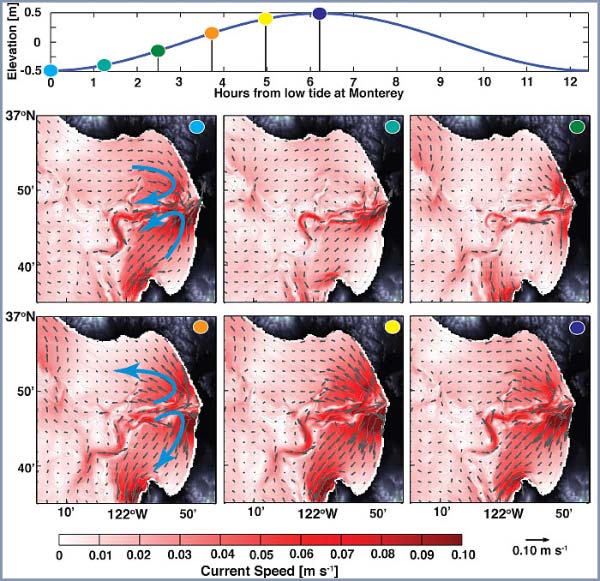
A high-resolution (250 m) primitive equation model is used to simulate the depth-averaged M2 currents in Monterey Bay. The depth-averaged currents have a complex pattern with magnitudes in excess of 0.1 ms-1 near Moss landing. During the second half of flood (ebb) tide, the flow is into (out of) the bay through the canyon but out of (into) the bay over the shelf. This flow pattern is not evident in a diagnostic simulation (does not permit internal waves), implying a feedback between the internal tides and the pressure gradient in the bay. |
Flow in Through the Canyon and Out Over the Shelf Time-slices (below) show that at low tide, the depth-averaged currents are into the bay over the shelf regions, with the strongest currents, up to 0.1 ms-1, on the shelf south of the canyon head. The upper canyon represents a convergence zone between the southward depth-averaged currents on the northern shelf and the northward currents on the southern shelf. The water entering the upper canyon is funneled out of the bay through and above the canyon. As flood tide progresses, the flow into the bay over the shelf and out of the bay through the canyon weakens before reversing. From mid-flood onwards, depth-averaged flows on the Monterey Bay shelf are out of the bay with flow in the canyon balancing the outward flow as well as the increasing water level. |
|
 |
||
|
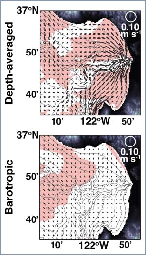
Depth-Averaged Does Not Equal Barotropic The depth-averaged ellipses from the 3-D simulation (below) rotate clockwise over the canyon (white) and counter-clockwise over the shelf (light red shading). This difference in rotation direction leads to convergences and divergences near the canyon rim. The magnitudes intensify within the bay. The barotropic currents (from the diagnostic model) bear no resemblance to this pattern. The magnitudes are similar to offshore, and the convergence zone along the canyon rim does not exist.  |
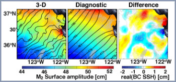
Reason: Internal Tides Alter Pressure Gradient Allowing internal waves in the model changes the pressure gradient (surface elevation phase) from approximately north-northwest / east-southeast (alongshore, in the diagnostic simulation) to locally east-west (onshore, in the 3-D simulation). Although, the baroclinic SSH is only ~4% of the barotropic when combined with the bay topography (presence of the canyon and open embayment) it significantly changes the depth-averaged flow. Implications Having concurrent transports into and out of the bay allows the transport in one direction (e.g., into the bay) to exceed the tidal prism. Integrating the positive u-velocities across the mouth over half a M2 tidal cycle gives 2x10⁹ m3 entering the bay, four times the tidal prism. The total east-west transport in half a tidal cycle is 0.47x10⁹ m3. This work suggests mass conservation will result in the depth-averaged tidal currents transporting water from below the canyon rim over the shelf during flood tide.  |
|