|
Pilot Studies on Lake Washington |
Coastal Washington Survey Cruise |
|

|

|
|
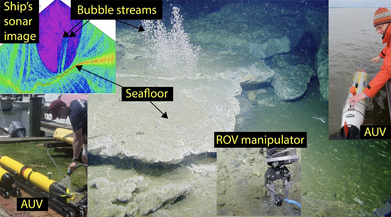
Methane is a potent greenhouse gas, and is released into the ocean from the seafloor as gas bubbles via methane seeps. Despite the prevalence of seeps along continental margins, data is limited, and their impacts on the ocean and atmosphere, both positive and negative, are poorly understood. To advance our knowledge about methane seeps, we are pursuing an approach to map and characterize methane seeps over wide areas. We are using easily deployable and relatively inexpensive autonomous underwater vehicles (AUVs) equipped with imaging sonars and custom sensors to find and map seeps and measure associated bubbles and dissolved methane right at the source and up through the water column. |
|
Seeps are Ubiquitous on the Cascadia Margin |
Goals + Objectives |
|
|
Recent efforts to map seafloor methane seeps have shown them to be ubiquitous at widely varying depths along the coastal zone from Vancouver Island to northern California – a region known as the Cascadia Margin. More than 1300 emission sites have been discovered to date. Autonomous undersea vehicles (AUVs) will be deployed on the coastal ocean off Oregon and Washington to characterize several methane emission sites at depths up to 500 m. |
|

Clockwise from left: bubble streams detected in sonar data, bubble streams escaping from the seafloor, a REMUS 100 AUV, temperature measurements being taken by ROV at a seep site, and the VT-690 AUV. Images courtesy of Ocean Exploration Trust (ROV captures) and NOAA Pacific Marine Environmental Laboratory (sonar image). |
|
NOAA Ocean Exploration |
|
This research is funded by NOAA Ocean Exploration beginning in fiscal year 2022. The research team responded to a proposal solicitation to conduct or support ocean exploration resulting in outcomes that provide or enable initial assessments about unknown or poorly understood regions of U.S. waters. |
|
Methane bubbles rising through the ocean and entering the atmosphere as a powerful greenhouse gas is not yet well understood. What is know well right now is that methane remaining in the ocean oxidizes, consumes oxygen, and produces carbonic acid. The oxidation of seep methane is an important contributor to hypoxia (low oxygen dead zones) and ocean acidification. Methanogenesis More than half of the global organic matter produced in the ocean's photic zone by biological production falls to the seafloor in the coastal ocean. This organic matter is buriede and forms sediments that accumulate over time. Beneath the seafloor where oxygen is depleted, the organic matter is transformed via microbe into reduced carbon compounds, including methane. Methane produced in the deeper sediment layers then migrates upward towards the seafloor. Under certain conditions, methane is released from the seafloor as bubbles and in dissolved form at methane seeps. |
|
VT-690 |
REMUS 100 |
|
|
690 AUVs developed at Virginia Tech. Univ. weight less than 100 lbs, making them easily launched from smaller craft (2 people) or by a ship's davit. Working depth: 500 m Science payload: High-resolution 3D side-scan sonar Navigation: GPS at surface and DVL/IMU underwater with on-wya-travel-time synchronous ranging from surface ship and other AUVs Autonomy: adaptive sampling algorithms that enable the VT-690 to sense the local environment and alter their sampling based on that information |
These commercial AUVs are built by Hydroid, Inc. Working depth: 100 m Science payload: high-resolution Teledyne BlueView 2D forward looking sonar, dissolved gas sensors, upward and downward looking ADCPs Navigation: combination of GPS at the sea surface and LBL while submerged Autonomy: to map a seep's flare, the AUV will follow repeat pre-programmed mow-the-lawn operations at different heights above the seabed |
|
Technical Approach |
|
The Cascadia Margin presents an excellent opportunity to assess the role that methane seeps have in a changing ocean. Shipboard surveys have mapped nearly 40% of the approximately 800 km long and 100 km wide Cascadia Margin, identifying nearly 3500 methane bubble streams clustered into more than 1300 methane emission sites. |
|
Seep Surveys |
Water Column Sampling |
|
|
Upon arrival at a targeted seep site, the activity of that seep will be evaluated using a custom multibeam echosounder. We will confirm there is a relatively large and persistent flare observed on the ship's sonar. Then, AUVs will be deployed witha relatively short reconnaissance grid-pattern mission. The AUVs will then be recovered and the data reviewed, establishing a more accurate position for the bubble stream's source on the seafloor. Building on this information, longer duration missions will characterize: 1. Variability in the flare's shape and size in the water column 2. temporal variability in the bubble plume source and gas flux over a tidal cycle |
We will interchange AUV tracking for CTD sampling and water-column multibeam sonar mapping when the AUVs are recharging. We will conduct vertical CTD casts over the seep sites that are identified with bubbles reaching high in the water column, and potentially making it all the way to the surface. Water samples for chemical analysis will be collected using Niskin bottles mounted on the CTD rosette. |


