For more information, contact Ed Belcher at (425) 488-1331
Locating mines or other objects in turbid water is a very time-consuming activity. The Diver-Held Sonar was designed to expedite the search. It combines a high resolution 750 kHz, 64-beam sector sonar and a tracking module that together allow the diver to find and identify objects in turbid water, record their images, and store their positions.

The 34-lb sonar uses acoustic lenses to form the high resolution image. The lenses do not use power and have no magnetic signature. The image is focused by sliding the top center knob forward or aft. The transducer at the back of the sonar is part of the Swimmer Inshore Navigation System1 that allows divers to swim accurate search grids and obtain Cartesian locations (x ,y) of objects.
 |
 |
|
The lens is above the electronics.
|
The tracking transducer is above the rear endcap. The focus control is forward of the tracking transducer. The rear endcap has four thumb switches, a transmit level control, and connectors for the mask-mounted display and data transfer. |
 |
 |
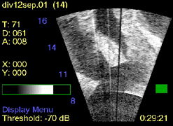
| This is one of two display pages the diver can select on his mask display. In this case, the image shows an upside down rowboat approximately 14 yards awayfrom the diver. The display is updated between 6 and 9 times/s. In addition to the sonar image, the diver can read: water temperature (° F), sonar depth in ft; sonar altitude in ft; sonar location (X,Y) in yd; sonar control menus (Display Menu); elapsed time (hr:min:sec); and battery status (green square). |
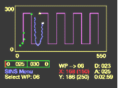
This display page shows the search grid, the diver's current location and his track, the current way-point, and the legs to follow in the search grid. When a diver marks a target with the sonar, that location is marked on the grid with a green "+." In addition to the track, the diver can read: compass heading in deg; current way-point (WP) number; depth in ft; altitude in ft; current sonar position in yd ; current way-point position in yd; and elapsed time in mission. |